
National Register of Historic Places listings in Pennington County, South Dakota facts for kids

Welcome to Pennington County, South Dakota! This area is full of amazing places that have been around for a long time and hold special stories. These places are so important that they are listed on the National Register of Historic Places. Think of this register as a special list that helps protect buildings, sites, and objects that are important to the history of the United States.
In Pennington County, there are over 60 places on this list! These include old buildings, cool natural spots, and even entire historic areas. Let's explore some of these fantastic locations and learn why they are so special.
Contents
Cool Historic Spots in Pennington County
Pennington County is home to many unique places that tell us about the past. From famous monuments to hidden gems, each one has a story.
Mount Rushmore National Memorial

One of the most famous places in the world is right here in Pennington County: Mount Rushmore National Memorial. This incredible monument features the faces of four U.S. Presidents – George Washington, Thomas Jefferson, Theodore Roosevelt, and Abraham Lincoln – carved into the side of a mountain. It was created by Gutzon Borglum and his team, and it took many years to finish. It's a symbol of American history and freedom. Mount Rushmore was added to the National Register way back in 1966!
Dinosaur Park

Imagine seeing giant dinosaurs! At Dinosaur Park in Rapid City, you can find seven large, green dinosaur sculptures on a hill overlooking the city. These statues were built in 1936 by the Civilian Conservation Corps (CCC), a group that helped people find jobs during the Great Depression. It's a fun place to visit and learn about prehistoric times, and it became a historic site in 1990.
Chapel in the Hills

The Chapel in the Hills in Rapid City is a stunning replica of an old Norwegian chapel from the 12th century. It was built in 1969 to celebrate Norwegian heritage and offer a peaceful place for visitors. It's a beautiful example of traditional architecture and was added to the National Register in 2012.
Historic Buildings in Rapid City
Rapid City has many buildings that tell the story of its growth.
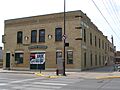
- The Calumet Hotel in Wasta, built in 1900, is a classic example of an old hotel that served travelers in the early days. It's a reminder of how people lived and traveled over a hundred years ago.
- The Pennington County Courthouse (1976) is where important decisions for the county are made. It's a grand building that shows the importance of local government.
- The Rapid City Carnegie Library (1981) was one of many libraries built across the country with money from Andrew Carnegie, a famous businessman. These libraries helped spread knowledge and education.
- The Rapid City High School (2010) is an important part of the city's educational history, showing how schools have changed over time.
- The Rapid City Masonic Temple (2016) is a building used by the Masons, a fraternal organization with a long history of community involvement.
Old Transportation and Industry Sites
- The Burlington and Quincy High Line Hill City to Keystone Branch (2003) is an old railroad line. Railroads were super important for moving goods and people across the country, helping towns grow.
- The Fairmont Creamery Company Building (2006) in Rapid City reminds us of the dairy industry and how food was processed and distributed in the past.
- The Milwaukee Road Freight House (1989) was a place where goods were loaded and unloaded from trains. It shows how important freight transportation was for businesses.
- The South Dakota Department of Transportation Bridge No. 52-575-383 (1999) and Bridge No. 52-824-300 (1999) are examples of important infrastructure that helped people travel and connect communities.
Mining and Ranching History
- The Harney Peak Lookout Tower, Dam, Pumphouse and Stairway (1983) near Custer is a historic site related to fire detection and water management in the Black Hills.
- The Harney Peak Tin Mining Company Buildings (1977) in Hill City show the history of mining in the area. People came to the Black Hills hoping to find valuable minerals.
- The Otho Mining District (2004) is another area that tells the story of mining operations and the challenges and successes of those who worked there.
- The Gramberg Ranch (1999) and the Josef and Marie Kudrna Homestead and Ranch (2015) are examples of historic ranches. These places show how early settlers lived and worked the land, raising animals and growing crops.
Other Interesting Places
- The Keystone School (1981) and Keystone Trading Company Store (1982) in Keystone give us a peek into what life was like in a small mining town.
- The Sitting Bull Crystal Cavern Dance Pavilion (1995) near Rockerville is a unique site that combines natural wonders (a crystal cavern) with a place for entertainment.
- The Wasta Rest Stop Tipi-Eastbound (2015) and Wasta Rest Stop Tipi-Westbound (2015) are modern structures designed to look like traditional Native American tipis, providing a unique rest stop experience for travelers.
Hidden History: Archeological Sites
Some historic places are not buildings you can visit. They are archeological sites, which means they are places where scientists study the remains of past human activity. These sites are often kept secret to protect them.
- Archeological Site No. 39PN376 (1993)
- Site No. 39 PN 57 (1982)
- Site No. 39 PN 108 (1982)
- Site No. 39 PN 438 (1982)
- Site No. 39 PN 439 (1982)
These sites help us learn about ancient cultures and how people lived thousands of years ago in Pennington County.
Images for kids
-
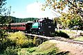
The Burlington and Quincy High Line railroad.
-
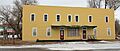
The historic Calumet Hotel in Wasta.
-
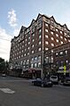
The old Harney Peak Hotel.
-
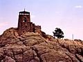
The Harney Peak Lookout Tower.
-
The Rapid City Garage in 1911.
-
A view of the Rapid City Historic Commercial District.


.jpg)


