
National Register of Historic Places listings in Platte County, Missouri facts for kids

Have you ever wondered about the old buildings and special places in your town? Many places across the United States are so important because of their history that they are added to a special list called the National Register of Historic Places (NRHP). This list helps protect these places and makes sure everyone can learn about their past.
Platte County, Missouri, is a place with a rich history, and it has 16 different properties and areas listed on the National Register. These places include old schools, grand houses, important archeological sites, and even a historic bridge! Let's explore some of these fascinating spots in Platte County.
What is the National Register of Historic Places?
The National Register of Historic Places is the official list of the nation's historic places worth saving. It's part of a program run by the United States government to identify and protect important historical sites. When a building, structure, object, site, or district is added to the Register, it means it has special historical, architectural, or archaeological importance.
Why are places added to the Register?
Places are added to the NRHP for many reasons. Maybe a building is a great example of a certain type of architecture, or it was the home of a famous person. Perhaps an archeological site holds clues about ancient cultures, or a district shows how a town grew over time. Being on the Register helps people understand the history of a place and encourages its preservation.
Historic Places in Platte County
Platte County is full of interesting history, from ancient times to more recent events. Here are some of the special places that have earned a spot on the National Register.
Schools and Learning Centers
Some buildings are important because of their role in education.
Benjamin Banneker School
The Benjamin Banneker School, located in Parkville, was added to the Register in 1995. This school is important because it represents a time when education was changing in the area. It stands at 31 West Eighth Street and has a significant story in the community's history.
Charles Smith Scott Memorial Observatory
Also in Parkville, the Charles Smith Scott Memorial Observatory is a unique historic site. It was listed in 1992 and is located at 8700 River Park Drive. Observatories are places where people study the stars and planets, and this one has played a part in the scientific and educational history of the region.
Important Buildings and Homes
Many historic places are buildings that tell us about how people lived and worked in the past.
Frederick Krause Mansion
The Frederick Krause Mansion in Platte City is a beautiful old house that was added to the Register in 1978. Located at 3rd and Harrel Ferrel Drive, this mansion gives us a glimpse into the grand homes of the past. It shows the architectural styles that were popular when it was built.
Mackay Building
The Mackay Building is part of Park College in Parkville. It was listed in 1979. College buildings often have long histories and are central to the stories of the institutions they belong to. The Mackay Building is an important part of Park College's heritage.
Platte County Courthouse
The Platte County Courthouse, found in Platte City, is another significant building. It was added to the Register in 1979 and stands at 3rd and Main Streets. Courthouses are often the heart of a county's government and community life, and this one has seen many important events over the years.
TWA Administrative Offices Building
Located in Kansas City (but within Platte County), the TWA Administrative Offices Building was listed in 2007. This building, at 11500 Ambassador Drive, is a reminder of the history of air travel and the Trans World Airlines (TWA) company, which played a big role in aviation.
Archeological Sites
Some of the oldest historic places are not buildings, but sites where ancient people once lived. These are called archeological sites.
Babcock Site
The Babcock Site, near Waldron, was added to the Register in 1973. Archeological sites like this one are very important because they contain artifacts and clues about the lives of people who lived thousands of years ago. To protect these clues, the exact address is often kept private.
Deister Archeological Site
Another archeological treasure is the Deister Archeological Site, located near Kansas City. It was listed in 1970. These sites help scientists learn about early cultures and how they interacted with the land.
Renner Village Archeological Site
The Renner Village Archeological Site in Riverside was recognized in 1969. It's located in Renner-Brenner Site Park. This site provides valuable information about ancient villages and the people who built them in this area.
Sugar Creek Site
Near Weston, the Sugar Creek Site was listed in 1973. Like other archeological sites, it holds secrets from the past, helping us understand the history of human settlement in Platte County.
Other Notable Historic Places
Platte County also has other types of historic listings, including churches, industrial sites, and even a bridge.
McCormick Distillery
The McCormick Distillery in Weston was listed in 1974. This site, located on MO JJ, is important for its role in the history of industry and manufacturing in the region.
Missouri District Warehouse
Also in Weston, the Missouri District Warehouse at 357 Main Street was added to the Register in 2010. Warehouses often play a key role in trade and transportation history.
Pleasant Ridge United Baptist Church
The Pleasant Ridge United Baptist Church, near Weston, was listed in 2002. It stands at the junction of MO P and Woodruff Road. Churches are often central to a community's social and spiritual history.
Waddell "A" Truss Bridge
The Waddell "A" Truss Bridge in Parkville was added to the Register in 1991. This bridge, found in English Landing Park over Rush Creek, is a great example of early bridge engineering and design.
Washington Chapel C.M.E. Church
The Washington Chapel C.M.E. Church, located at 1137 West Street in Parkville, was listed in 1992. Like other historic churches, it tells a story about the community's past and its development.
Weston Historic District
Sometimes, not just one building, but a whole area is considered historic. The Weston Historic District in Weston was listed in 1972. This district is roughly bounded by Summit, Rock, Market, and Ashley streets. It includes many buildings that together show what the town was like in earlier times.
Images for kids
-
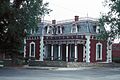
The historic Frederick Krause Mansion in Platte City.
-
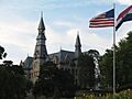
The Mackay Building at Park College in Parkville.
-
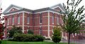
The Platte County Courthouse in Platte City.


