
National Register of Historic Places listings in Polk County, Arkansas facts for kids

This page lists special places in Polk County, Arkansas, that are part of the National Register of Historic Places. This is a list of important buildings, areas, and objects that are recognized for their historical value in the United States.
Being on this list means a place is important to the history of the country, the state, or the local area. It helps protect these places so future generations can learn from them. In Polk County, there are 30 places currently on this list. Two other places were once listed but have since been removed.
Historic Places in Polk County
Polk County is home to many interesting historical sites. These places tell stories about how people lived, worked, and built communities long ago. Let's explore some of them!
Bard Springs Area
The Bard Springs area is located northwest of Athens, deep within the Ouachita National Forest. This area has several structures that were built to help people enjoy nature.
Bard Springs Bathhouse
The Bard Springs Bathhouse was built for visitors to use when they came to enjoy the natural springs. It's a reminder of how people used to relax and enjoy the outdoors.

Bard Springs Dams
There are two dams in the Bard Springs area, Bard Springs Dam No. 1 and Bard Springs Dam No. 2. These dams helped create water features for recreation. They show the engineering skills of the past, even in natural settings.


Bard Springs Picnic Shelter
The Bard Springs Picnic Shelter was a place where people could gather and eat outdoors. Sadly, this shelter is no longer standing today.
Scenic Overlooks
Polk County offers beautiful views, and some spots are recognized for their natural beauty and historical importance.
Buckeye Vista Overlook
The Buckeye Vista Overlook is a special spot where you can see amazing views of the surrounding forest and mountains. It's a great place to stop and appreciate nature.

Sugar Creek Vista Overlook
Another wonderful viewing spot is the Sugar Creek Vista Overlook. Like Buckeye Vista, it offers stunning landscapes and is a popular place for visitors to enjoy the scenery.

Mena's Historic Buildings
The city of Mena has many buildings that are important to its history and are listed on the National Register.
Ebenezer Monument
The Ebenezer Monument is a significant landmark in Mena, located at the junction of 9th and Church Streets. Monuments like this often tell stories of important events or people from the past.

Elks Lodge
The Elks Lodge building at 500 Mena Street is another historic site. Fraternal organizations like the Elks often had grand buildings that served as community centers.

C.E. Foster House
The C.E. Foster House is an old home located west of Mena. Historic houses give us a glimpse into the architectural styles and daily lives of people from earlier times.

Janssen Park
Janssen Park is a historic park in Mena. Parks are important for communities, providing green spaces for recreation and relaxation. This park has been a central gathering place for many years.

Mena Commercial Historic District
The Mena Commercial Historic District includes several streets in Mena's downtown area. This district is important because it shows how the city's businesses and shops developed over time. It's like stepping back in time to see old storefronts and buildings.

Mena Kansas City-Southern Depot
The Mena Kansas City-Southern Depot is an old train station. Train depots were once very busy places, as trains were a main way to travel and transport goods. This depot played a big role in Mena's growth.

National Guard Armory
The National Guard Armory building in Mena was used by the National Guard, a part of the military. Armories are places where soldiers train and store equipment.

Old Post Office
The Old Post Office building at 520 N. Mena Street served as the city's post office for many years. Post offices were vital for communication and connecting communities.
.JPG)
Polk County Courthouse
The Polk County Courthouse is a grand building where important legal and government decisions for the county are made. Courthouses are often central to a town's history and civic life.

St. Agnes Catholic Church
St. Agnes Catholic Church is a beautiful church located at the junction of 8th and Walnut Streets. Churches are often important historical and community landmarks.

Judge Benjamin Shaver House
The Judge Benjamin Shaver House is another historic home in Mena. It belonged to Judge Benjamin Shaver, an important person in the community's past.

Studebaker Showroom
The Studebaker Showroom at 519 Port Arthur was once a place where Studebaker cars were sold. This building represents a time when cars were becoming popular and changing how people traveled.

Other Notable Sites
Polk County has other unique historical listings beyond its main towns.
Mountain Fork Bridge
The Mountain Fork Bridge crosses Mountain Fork Creek. Old bridges are often engineering marvels of their time and are important for connecting different areas.

State Line Marker
The State Line Marker is a special marker located about 17 miles northwest of Mena on Highway 88. It marks the border between Arkansas and Oklahoma! It's a cool spot to see where two states meet.

Shady Lake Recreation Area
The Shady Lake Recreation Area is another important historical district within the Ouachita National Forest, near Athens. Many of its structures were built by the Civilian Conservation Corps (CCC) during the Great Depression, a program that put young men to work building parks and infrastructure.
Shady Lake Bathhouse
The Shady Lake Bathhouse was built for visitors to use when enjoying the lake. It's similar to the one at Bard Springs, showing the style of recreation facilities built during that era.

Shady Lake Caretaker's House
The Shady Lake Caretaker's House was where the park's caretaker lived. This person would have managed the recreation area and helped visitors.
Shady Lake CCC Bridges
There are two historic bridges built by the CCC in the Shady Lake area: Shady Lake CCC Bridge No. 1 and Shady Lake CCC Bridge No. 2. These bridges are examples of the excellent work done by the CCC.


Shady Lake Dam
The Shady Lake Dam helped create Shady Lake itself, providing a beautiful spot for boating, fishing, and swimming.

Shady Lake Picnic Pavilion
The Shady Lake Picnic Pavilion is a large shelter where groups can gather for picnics and events. It's a great example of the rustic style of architecture used in national forests.

Shady Lake Recreation Area Historic District
The entire Shady Lake Recreation Area Historic District is listed because of all these historic structures working together to create a special place for people to enjoy nature.
Former Listings
Sometimes, a place that was once on the National Register of Historic Places might be removed. This can happen if the building is torn down, or if it changes so much that it loses its historical importance.
Two places in Polk County were once listed but are no longer:
- The Bee Mountain Fire Tower near Vandervoort, which was built by the Civilian Conservation Corps in 1938.
- The Scoggin House in Mena.
Images for kids
-
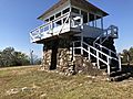
Tall Peak Fire Tower

