
National Register of Historic Places listings in Prescott, Arizona facts for kids
Prescott, Arizona, is a city with a rich history! Many of its old buildings and areas are so special that they are listed on the National Register of Historic Places. This is like a special list kept by the United States government to protect important places. When a place is on this list, it means it has a unique story or design that should be saved for future generations.
This article shares some of the amazing historic places you can find in Prescott. There are 65 of these special spots in Prescott, and even more in the wider Yavapai County. Let's explore some of them!
Contents
Historic Buildings in Prescott
Prescott has many individual buildings that tell tales of the past. These places were once homes, businesses, or important community centers.
Homes with History
Many beautiful old houses in Prescott are on the National Register. They show us how people lived long ago.
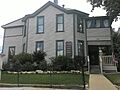
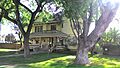
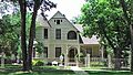
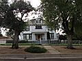
- Arizona Pioneers' Home
This large building at 300 S. McCormick Street was built in 1909. It's a retirement home for people who helped settle Arizona. It sits on a hill and offers great views of Prescott.
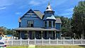
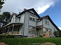
- Blumberg House
Located at 143 N. Mt. Vernon, this house was listed in 1978.
- Brinkmeyer House
You can find this house at 605 W. Gurley Street. It was also listed in 1978.
- Burmister/Timerhoff House
This historic home is at 116 S. Mt. Vernon.
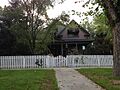
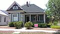
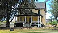
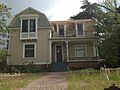
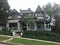
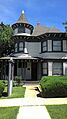
- Clark House
The Clark House is at 109 N. Pleasant Street.
- Curtis Cottage
This charming cottage is at 125 S. McCormick Street. It was added to the list in 1993.
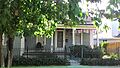
- Day House
Located at 212 E. Gurley, the Day House was listed in 1978.
- Detwiler House
This house is at 310 N. Alarcon Street.
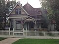
- Drake House
Find the Drake House at 137 N. Mt. Vernon.
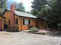
- Charles H. Dunning Log Cabin
This rustic log cabin at 811 Boulder Drive was listed in 1993.
- Fredericks House
This home is at 202 S. Pleasant Street.
- Fisher/Goldwater House
Located at 240 S. Cortez Street, this house has a connection to the Goldwater family.
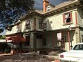
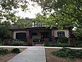
- Gage/Murphy House
This house is at 105 S. Alarcon.
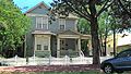
- Henry Goldwater House
Another Goldwater family home, this one is at 217 E. Union Street and was listed in 1982.
- Hawkins House
The Hawkins House is at 122 S. Mt. Vernon.
- Hazeltine House
This house is at 202 S. Mt. Vernon.
- Head House
You can find the Head House at 309 E. Gurley.
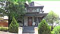
- Hill House
The Hill House is at 144 S. Park.
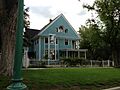
- Lawler-Hetherington Double House
This unique double house is at 223 E. Union.
- Marks House
The Marks House is at 203 E. Union.
- Martin/Ling House
This house is at 125 N. Pleasant.
- Morin House
The Morin House is at 134 N. Mt. Vernon.
- Morrison House
This home is at 300 S. Marina.
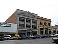
- Mulvenon Building
This building at 230 W. Gurley Street was listed in 1993.
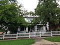
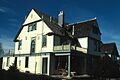
- Old Governor's Mansion
Located at 415 W. Gurley, this was once the home of Arizona's governor! Today, it's part of the Sharlot Hall Museum. It was listed way back in 1971.
- Otis House
The Otis House is at 113 N. Pleasant.
- Peter House
This house is at 211 E. Union.
- Roberts House
The Roberts House is at 136 N. Pleasant.
- A. W. Robinson Building
This building is at 115 N. Grove.
- Sewall House
The Sewall House is at 220 N. Mt. Vernon.
- Shekels House
This house is at 226 S. Cortez.
- Sloan House
The Sloan House is at 128 N. Mt. Vernon.
- Toltec Lodge
This interesting lodge at 228 High Street was listed in 2000.
- Wells House
The Wells House is at 303 S. Cortez.
- Wilder House
The Wilder House is at 346 S. Montezuma.
Important Public and Commercial Buildings
Prescott also has historic buildings that served the community or were important businesses.
- Elks Building and Theater
At 117 E. Gurley, this building was once a grand theater and meeting place. It was listed in 1978.
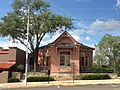
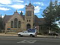
- First Congregational Church and Parsonage
This church and its parsonage (the minister's house) are at 216-220 E. Gurley. They were listed in 1978.
- James I. Gardner Store
This old store at 201 N. Cortez was listed in 1985.
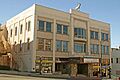
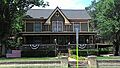
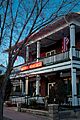
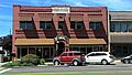
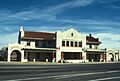
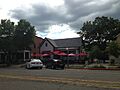
- Hassayampa Hotel
This beautiful hotel at 122 E. Gurley Street was designed in the Spanish Colonial Revival style by architect Henry Trost in 1927. It's still a working hotel today! It was listed in 1979.
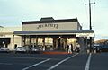
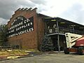
- Sam Hill Hardware
Located at 154 S. Montezuma, this building once housed a hardware store. It was listed in 1978.
- Samuel Hill Hardware Company Warehouse
The warehouse for Sam Hill Hardware is at 232 N. McCormick Street. It was listed in 1984.
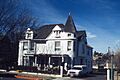
- Hotel Vendome
This hotel at 230 S. Cortez is still open for guests! It was listed in 1983.
- Kenwill Apartments
These apartments at 119-127 E. Goodwin Street were listed in 1988.
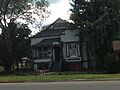
- Mormon Church
The former Mormon Church building at 126 N. Marina Street was listed in 1983. It was changed into a commercial building in 1982.
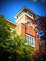
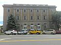
- Mountain States Telephone and Telegraph Exchange Building
This building at 116 N. Marina Street was important for communications. It was listed in 2004.
- Prescott Public Library
The old library building at 125 E. Gurley Street was a Carnegie library. It was listed in 1975 and is now an office building.
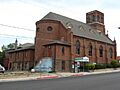
- Sacred Heart Catholic Church and Rectory
This church and rectory at 208 N. Marina were listed in 1978. Today, it's used as an art gallery!
- Santa Fe, Prescott and Phoenix Railroad Depot
This old train station on Cortez Street was listed in 1988. It was a busy place when trains were the main way to travel.
- US Post Office and Courthouse-Prescott Main
This important government building at 101 W. Goodwin Avenue was listed in 1985.
Other Unique Historic Places
Some listings are not just buildings but other interesting sites.
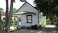
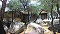
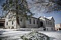
- Groom Creek School
This school is located southeast of Prescott in the Prescott National Forest. It was listed in 1992.
- Indian Peak Ruin (AR-03-09-06-116)
This is an ancient ruin from the Sinagua people, a Native American culture. Its exact location is kept secret to protect it. It was listed in 1989.
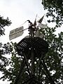
- Iron Turbine Windmill
This old windmill at 415 W. Gurley Street is part of the Sharlot Hall Museum. It was listed in 1981.
- Lynx Creek Bridge
This bridge is about 5.9 miles (9.5 km) east of Prescott on the Old Black Canyon Highway. It was listed in 1988.
- Palace Station District
About 23 miles (37 km) south of Prescott, this was a stagecoach station built in 1874. It was listed in 1976.
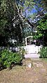
- Walker Charcoal Kiln
This old charcoal kiln is southeast of Prescott in the Prescott National Forest. It was used to make charcoal long ago and was listed in 1976.
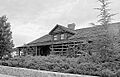
- Walnut Creek Ranger Station
This ranger station is northwest of Prescott in the Prescott National Forest. It was listed in 1993.
- Yavapai County Courthouse
The impressive courthouse at Courthouse Plaza was built in 1918 in the Greek Revival style. It's a very important landmark in Prescott and was listed in 1977.
Historic Districts in Prescott
Sometimes, it's not just one building that's historic, but a whole group of buildings or an entire neighborhood. These are called "historic districts."
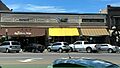
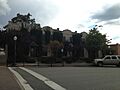
- Courthouse Plaza Historic District
This district is roughly around Gurley, Montezuma, Cortez, and Goodwin Streets. It includes the famous Courthouse Plaza, which is the heart of Prescott. It was listed in 1978.
- East Prescott Historic District
This area is roughly bounded by the old railroad tracks, N. Mt. Vernon Street, Carleton Street, and N. Alarcon Street. It was listed in 1989.
- Fleury's Addition Historic District
This district includes parts of Western and Gurley from Willow to Grove, and Willow, Garden, and Grove from Western to Gurley. It was listed in 1994.
- Fort Whipple-Department of Veterans Affairs Medical Center Historic District
Located at 500 State Route 89 N., this district includes the historic Fort Whipple, Arizona. It was listed in 1999.
- Hassayampa Historic District
This district is around 1089-1112 Old Hassayampa Lane and 1106 Country Club Drive. It was listed in 2003.
- Joslin and Whipple Historic District
This district includes S. Mt. Vernon, Virginia, Washington, and Arizona Streets. It was listed in 2000.
- Lynx Creek District
This historic area is east of Prescott and was listed in 1978.
- Mile High Park Historic District
This district is roughly along Oregon Avenue and Josephine Street from Gail Gardner Way and Lindberg Drive. It was listed in 1999.
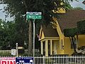
- North Prescott Townsite Historic District
This district is between Gurley, Sheldon, Alarcon, and Summit Streets. It was listed in 2009.
- Pine Crest Historic District
This area is roughly bounded by San Carlos Street, Coronado Avenue, and Yavapai, Apache, and Mohave Drives. It was listed in 1989.
- Prescott Armory Historic District
This district is roughly bounded by E. Gurley, E. Willis, N. Arizona, E. Sheldon, and N. Rush Streets. It was listed in 1994.
- South Prescott Townsite
This historic area is roughly bounded by Alarcon, Montezuma, Union, and Leroux Streets. It was listed in 1998.
- West Prescott Historic District
This large district is roughly bounded by Gurley Drive, Park Avenue, Country Club Drive, Vista Drive, and Coronado Avenue. It also includes specific addresses on Glenwood Avenue and Moreland Circle. It was listed in 1989.
- Whipple Heights Historic District
This district includes E. Gurley, N. Virginia, Washington, and E. Moeller Streets. It was listed in 2000.
Former Listings
Sometimes, a historic place might be removed from the National Register. This can happen if the building is changed too much, or if it is unfortunately destroyed. Here are a few places in Prescott that were once listed but are no longer on the Register:
- Curtis Hall
Located at 133 S. McCormick, this building was listed in 1978 but removed in 1992.
- Goldwater Mercantile
This store at 127 S. Cortez was listed in 1978 but removed in 1992.
- Mulvenon House
This house at 233 S. Cortez was listed in 1978 but removed in 1992.
Images for kids
-
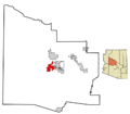
Location of Prescott in Arizona
-
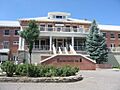
The Arizona Pioneers' Home, a retirement complex overlooking Prescott.
-
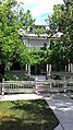
The Blumberg House.
-
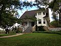
The Brinkmeyer House.
-
The Burmister/Timerhoff House.
-
The Clark House.
-
Buildings in the Courthouse Plaza Historic District.
-
The Curtis Cottage.
-
The Day House.
-
The Detwiler House.
-
The Drake House.
-
The Charles H. Dunning Log Cabin.
-
A building in the East Prescott Historic District.
-
The Elks Building and Theater.
-
The First Congregational Church and Parsonage.
-
The Fisher/Goldwater House.
-
Fort Whipple.
-
The Gage/Murphy House.
-
The James I. Gardner Store.
-
The Henry Goldwater House.
-
A building in the Hassayampa Historic District.
-
The Hassayampa Hotel.
-
The Hawkins House.
-
The Hazeltine House.
-
The Head House.
-
The Hill House.
-
The Sam Hill Hardware building.
-
The Samuel Hill Hardware Company Warehouse.
-
The Hotel Vendome.
-
The Iron Turbine Windmill, part of the Sharlot Hall Museum.
-
The Kenwill Apartments.
-
The Lawler-Hetherington Double House.
-
The Marks House.
-
The Martin/Ling House.
-
The Morin House.
-
The former Mormon Church.
-
The Morrison House.
-
The Mulvenon Building.
-
The Old Governor's Mansion, now part of the Sharlot Hall Museum.
-
The Otis House.
-
The Peter House.
-
The Prescott Armory.
-
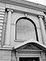
The old Prescott Public Library building.
-
The Roberts House.
-
The A. W. Robinson Building.
-
The Sacred Heart Catholic Church and Rectory.
-
The Santa Fe, Prescott and Phoenix Railroad Depot.
-
The Sewall House.
-
The Shekels House.
-
The Sloan House.
-
The Toltec Lodge.
-
The US Post Office and Courthouse–Prescott Main.
-
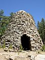
The Walker Charcoal Kiln.
-
The Wells House.
-
The Wilder House.
-
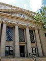
The Yavapai County Courthouse.


