
National Register of Historic Places listings in Presidio County, Texas facts for kids

Welcome to Presidio County, Texas! This area is full of amazing history, and many special places here are listed on the National Register of Historic Places. This list helps protect important buildings, sites, and areas that tell us about the past.
In Presidio County, there are six historic districts (larger areas with many historic features) and seven individual properties (single buildings or sites) that are on this important list. Some of these places are also recognized by the state of Texas as historic landmarks, meaning they are extra special!
Contents
Discovering Presidio County's Historic Places
Presidio County is in West Texas, known for its wide-open spaces and unique history. Let's explore some of the cool places that are protected because of their historical importance.
Historic Buildings and Forts
Many of the listed sites are old buildings or forts that played a big role in the area's development.
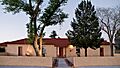
Building 98, Fort D.A. Russell
Building 98 is located on West Bonnie Street in Marfa. It's part of the old Fort D.A. Russell. This building is recognized as a Recorded Texas Historic Landmark, meaning it has a special place in Texas history.
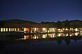
El Paisano Hotel
The El Paisano Hotel is a famous building in Marfa, found at North Highland and West Texas Streets. This beautiful hotel was built in 1930 and is known for its Spanish-style architecture. It's also a Recorded Texas Historic Landmark.
Fort D.A. Russell Historic District
The Fort D.A. Russell Historic District covers a larger area of the old fort in Marfa. Today, this area is home to the Chinati Foundation, an art museum that uses many of the old fort buildings. It's a great example of how old places can find new life!
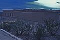
Fort Leaton
About 4 miles (6 km) east of Presidio on FM 170, you'll find Fort Leaton. This historic fort is now a State Historic Site managed by the Texas Parks and Wildlife Department. It's a great place to learn about the early days of settlement in this part of Texas.
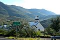
Fortin de la Cienega
The Fortin de la Cienega is another historic fort site, located about 15 miles (24 km) northeast of Shafter on Cienega Creek. These old forts were important for protection and trade in the past.
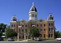
Presidio County Courthouse
The Presidio County Courthouse is a grand building located in the Public Square in Marfa. It's not just a courthouse; it's also a State Antiquities Landmark and a Recorded Texas Historic Landmark. This means it's one of the most important historic buildings in the state.
Historic Districts and Archeological Sites
Beyond single buildings, some larger areas are protected because they contain many historic features or important clues about ancient times.
El Fortin del Cibolo Historic District
The El Fortin del Cibolo Historic District is about 4 miles (6 km) northwest of Shafter. This district is a Recorded Texas Historic Landmark, showing its importance to the history of the region.
La Junta de los Rios Archeological District
The La Junta de los Rios Archeological District is a very important site near Presidio. Its exact location is kept private to protect the ancient artifacts found there. This area was a meeting point for two rivers, and people have lived here for thousands of years, leaving behind many clues about their lives.
La Morita Historic District
Another historic district, La Morita Historic District, is located about 5 miles (8 km) southwest of Shafter. These districts help preserve the overall look and feel of historical communities.
Shafter Historic Mining District
The Shafter Historic Mining District is about 20 miles (32 km) north of Presidio on U.S. 67. This area was once a busy mining town, and the district preserves the history of mining in Texas.
Tapalcomes
Tapalcomes is another historic site near Redford, but its exact address is restricted to protect its historical value.
Images for kids
-
Building 98, Fort D.A. Russell
-
El Fortin del Cibolo Historic District
-

Entry to El Paisano Hotel
-
Fort Leaton
-

Fortin de la Cienega
-

La Junta de los Rios Archeological District
-
Presidio County Courthouse
-
Shafter Historic Mining District
-

Tapalcomes

.jpg)


