
National Register of Historic Places listings in Rock Hill, South Carolina facts for kids

Rock Hill, South Carolina, is a city with a rich history! Many of its important buildings and places are listed on the National Register of Historic Places. This is like a special list kept by the United States government. It helps protect places that are important to American history, architecture, archaeology, engineering, or culture. When a place is on this list, it means it's recognized for its special value and efforts are made to preserve it for future generations.
This article will tell you about some of the amazing historic places in Rock Hill that are on this important list. There are 27 such places in Rock Hill, out of 58 in all of York County. Let's explore them!
Historic Buildings and Homes in Rock Hill
Rock Hill has many old buildings and homes that tell stories of the past. These places are preserved so we can learn about how people lived and worked long ago.
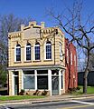
Afro-American Insurance Company Building
This building, located at 558 S. Dave Lyle Boulevard, was added to the National Register in 1992. It's a reminder of important businesses in the African-American community.
Anderson House
The Anderson House, found at 227 Oakland Avenue, joined the list in 1982. It was designed by a famous architect named George Franklin Barber. Imagine living in a house designed by someone so well-known!

Bleachery Water Treatment Plant
This plant on Stewart Avenue became a historic site in 2008. It shows how important water treatment was for industries in the past.
Catawba Rosenwald School
Located at 3071 S. Anderson Road, this school was listed in 2013. Rosenwald Schools were built across the South to provide better education for African-American children during a time of segregation. This school is a symbol of progress and community effort.

Ebenezer Academy
The Ebenezer Academy, at 2132 Ebenezer Road, was recognized in 1977. Academies like this were important places for learning before public schools were common.
.jpg)
First Presbyterian Church
This beautiful church at 234 E. Main Street was added to the list in 1992. Churches often serve as important community centers and have rich histories.

Hermon Presbyterian Church
Another significant church, Hermon Presbyterian, is at 446 Dave Lyle Boulevard. It was listed in 1992 and has been a central part of its community for many years.

McCorkle-Fewell-Long House
You can find this historic home at 639 College Avenue. It was added to the National Register in 1980. Old homes like this give us a peek into the past lives of Rock Hill families.

Mount Prospect Baptist Church
Located at 339 W. Black Street, this church was listed in 1992. It represents the spiritual and social life of its community.

People's National Bank Building
The People's National Bank Building, at 131-133 E. Main Street, joined the list in 1999. Banks are often important landmarks in a city's downtown area, showing its economic history.

Rock Hill Body Company
This building at 601 W. Main Street was listed in 2008. It reminds us of the types of industries that once thrived in Rock Hill.

Rock Hill Cotton Factory
The Rock Hill Cotton Factory, at 215 Chatham Street, was added in 1992. Cotton factories were very important to the economy of South Carolina. This factory shows the city's industrial past.

Rock Hill Printing and Finishing Company
This large company, located at 400 W. White Street, was listed in 2013. It played a big role in the textile industry, which was a major part of the South's economy.
Stokes-Mayfield House
The Stokes-Mayfield House, at 353 Oakland Avenue, was added in 1984. It's another example of the beautiful historic homes in Rock Hill.

Tillman Hall
Found on Oakland Avenue on the Winthrop College campus, Tillman Hall was listed in 1977. It's a key building at Winthrop University, a well-known college.
.jpg)
US Post Office and Courthouse
This important government building at 102 Main Street was added in 1988. It served as a place for mail and legal matters for many years.
_1933.jpg)
White House
The White House, at 258 E. White Street, is one of the oldest listings, added in 1969. It's a significant piece of Rock Hill's early history.

Withers Building
Also on Oakland Avenue, the Withers Building was listed in 1981. It's another historic part of the Winthrop University campus.
.jpg)
Historic Districts and Areas
Sometimes, it's not just one building that's historic, but a whole group of buildings or an area. These are called historic districts.
Charlotte Avenue-Aiken Avenue Historic District
This district includes parts of Aiken Avenue and Charlotte Avenue. It was listed in 1992. Walking through this area feels like stepping back in time!

Highland Park Manufacturing Plant and Cotton Oil Complex
This large historic area includes 869 Standard Street and 732 and 737 E. White Street. It was added in 1992. It shows how important manufacturing was to Rock Hill's growth.

Laurelwood Cemetery
Cemeteries can also be historic! Laurelwood Cemetery is bordered by Laurel, W. White, Stewart, and W. Main Streets. It was listed in 2008 and is a place of quiet history.

Marion Street Area Historic District
This district covers parts of Marion Street and Center Street. It was listed in 1992. Historic districts help protect the unique look and feel of older neighborhoods.

Reid Street-North Confederate Avenue Area Historic District
This district includes Reid Street and N. Confederate Avenue between E. Main Street and E. White Street. It was added in 1992. It's another area where you can see many historic homes.

Rock Hill Downtown Historic District
The heart of Rock Hill, its downtown area, is also a historic district! It includes parts of S. Oakland Avenue and E. Main Street. It was listed in 1991, showing the importance of preserving the city's central area.

Winthrop College Historic District
This district covers the campus of Winthrop College along Oakland Avenue. It was listed in 1987. The historic buildings on campus are a big part of the college's identity.

Unique Historic Sites
Some historic places are not buildings but are still very important!
Nation Ford Fish Weir
This unique site is in the Catawba River, about 1200 feet upstream from the Nation Ford railroad trestle. It was listed in 2007. A fish weir is an ancient structure used to catch fish. This one shows how Native Americans lived and used the river long ago.
Images for kids
-
Afro-American Insurance Company Building

