
National Register of Historic Places listings in Searcy County, Arkansas facts for kids
Searcy County, Arkansas, is home to many special places that are listed on the National Register of Historic Places. This list helps protect buildings, sites, and objects that are important to history. Think of it like a special hall of fame for historic spots! These places tell us stories about how people lived, worked, and built communities in Searcy County long ago.
There are 51 different places in Searcy County that have earned a spot on this important list. Let's explore some of them!
Contents
Historic Buildings in Searcy County
Many of the historic places in Searcy County are old buildings that were once homes, stores, or important community centers.
Homes with History
Searcy County has many old houses that are listed as historic. These homes often show us how people lived in the past.
- The Aday-Stephenson House in Marshall was once an important home, though it is no longer standing today.
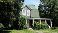
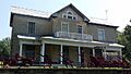
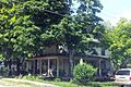
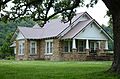
- The Guy Bartley House in Leslie is another historic home.
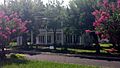
- The Bromley-Mills-Treece House on Main Street in Marshall gives us a peek into the past.
- The Dr. J.O. Cotton House in Leslie was the home of a doctor.
- The Dr. Sam G. Daniel House in Marshall is another historic doctor's home.
- The Bud Fendley House in Marshall is a well-preserved historic home.
- The Columbus Hatchett House in Leslie shows us how families lived long ago.
- The Benjamin Franklin Henley House in St. Joe is a significant historic home.
- The Dr. Cleveland Hollabaugh House in Leslie is another historic residence.
- The S.A. Lay House in Marshall is a historic home located near a main highway.
- The Leslie-Rolen House in Leslie is a historic home that tells part of the town's story.
- The Anthony Luna House in Marshall is another example of the county's historic homes.
- The Thomas Lynch House near Morning Star is a historic farm home.
- The Sam Marshall House near Morning Star is also a historic farm property.
- The J.M. McCall House in Marshall is a historic home on Spring Street.
- The J.C. Miller House in Leslie is a historic home.
- The Charley Passmore House in Marshall is a historic home on Campus Street.
- The Sanders-Hollabaugh House in Marshall is a historic home on Church Street.
- The Greene Thomas House near Leslie is a historic rural home.
Old Stores and Banks
Many old businesses in Searcy County are also on the historic register. These buildings were once busy places where people bought goods and handled money.
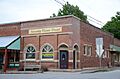
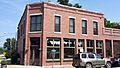
- The Bank of Marshall Building was an important financial center in Marshall.
- The Noah Bryan Store in Marshall was a general store where people bought everyday items.
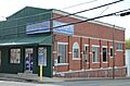
- The Farmers Bank Building in Leslie was a key part of the town's economy.
- The Mays General Store in Gilbert is a historic store building.
- The Meek Building in Leslie is a historic commercial building.
- The Oscar Redman Building in Marshall was another important store.
- The Treat Commercial Building in Leslie was a place where people did business.
- The Jasper E. Treece Building near Baker is a historic commercial building.
Important Community Buildings
Some buildings are important because they served the whole community.
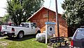
- The American Legion Post No. 131 in Leslie was a meeting place for veterans.
- The Mary Greenhaw Memorial Methodist Episcopal Church South in Marshall is a historic church.
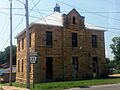
- The Old Searcy County Jail in Marshall is a historic building that once held prisoners.
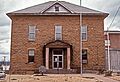
- The Searcy County Courthouse in Marshall is a very important building where local government decisions are made.
Railroad History
Railroads were very important for connecting towns and moving goods. Searcy County has historic railroad buildings.
- The Missouri and North Arkansas Depot-Leslie was a train station in Leslie.
- The St. Joe Missouri and North Arkansas Railroad Depot was the train station in St. Joe.
Other Interesting Historic Sites
Searcy County also has other unique historic places, including ancient sites and places for travelers.
- 3SE33 (also known as the Calf Creek site) is a major archaeological site along the Buffalo National River. This means it's a place where scientists have found old tools and signs of ancient human life.
- Cooper's Bluff Site near Snowball is another archaeological site, known for its rock art.
- The Gates-Helm Farm near Snowball is a historic farm property.
- The Henley Hotel in St. Joe was a place where travelers could stay.
- The Willmering Tourist Cabins Historic District in Silver Hill was a group of cabins for people traveling by car.
Images for kids
-
Location of Searcy County in Arkansas
-
American Legion Post No. 131
-
Bank of Marshall Building
-
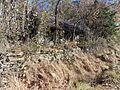
Guy Bartley House
-

Bates Tourist Court
-

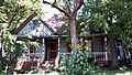
Bromley-Mills-Treece House
-

Noah Bryan Store
-
Campbell Post Office-Kuykendall General Store
-
Dr. Clay House
-
Dr. J.O. Cotton House
-
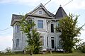
Dr. Sam G. Daniel House
-
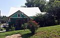
Farmers Bank Building
-

Bud Fendley House
-

Gates-Helm Farm
-

Mary Greenhaw Memorial Methodist Episcopal Church South
-
Columbus Hatchett House
-

Henley Hotel
-

Benjamin Franklin Henley House
-
Dr. Cleveland Hollabaugh House
-

S.A. Lay House
-
Leslie-Rolen House
-
Anthony Luna House
-

Mays General Store
-

J.M. McCall House
-
Meek Building
-
J.C. Miller House
-
Missouri and North Arkansas Depot-Leslie
-
Old Searcy County Jail
-

Charley Passmore House
-

Oscar Redman Building
-

St. Joe Missouri and North Arkansas Railroad Depot
-

Sanders-Hollabaugh House
-
Searcy County Courthouse
-
Greene Thomas House
-
Treat Commercial Building
-

Jasper E. Treece Building
-

Willmering Tourist Cabins Historic District


