
National Register of Historic Places listings in Stephenson County, Illinois facts for kids

Welcome to Stephenson County, Illinois! Did you know that many special places here are protected because of their history? These places are listed on the National Register of Historic Places. It's like a special club for buildings, sites, and objects that are important to American history, architecture, archaeology, engineering, or culture.
In Stephenson County, there are 16 places currently on this list, and two others that used to be. These listings help us remember and learn about the past, making sure these important spots are preserved for future generations, including you! Let's explore some of these cool historic sites.
Contents
Historic Buildings and Homes
Stephenson County is home to several interesting old buildings and houses that tell stories of the past.
Homes of Important People
Some houses are famous because of the people who lived in them.
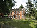
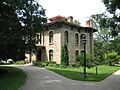
- The John H. Addams Homestead in Cedarville was the home of John H. Addams. His daughter, Jane Addams, became a very famous social reformer and won the Nobel Peace Prize! This house was added to the list in 1979.
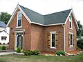
- The William Ritzman House in Orangeville, listed in 2000, is another example of a historic home.
Community Buildings
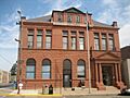
Many buildings served as important gathering places or government centers for their towns.
- The Freeport City Hall is where the city's government works. This building, listed in 2016, is a significant landmark in Freeport.
- In Orangeville, you'll find the AF and AM Lodge 687, a building that has been a meeting place for a long time, listed in 2003.
- The Central House in Orangeville, added in 1999, and the Union House also in Orangeville, listed in 2000, were likely important community hubs or hotels in their day.
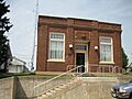
- The People's State Bank in Orangeville, listed in 2004, shows us what banks looked like in the past.
- The Stephenson County Courthouse in Freeport was listed in 1974. The original building was later replaced, but the site remains historically important.
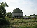
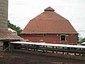
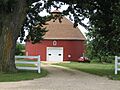
Unique Round Barns
Stephenson County is famous for its unique round barns. These barns are special because they are circular instead of rectangular. Farmers built them this way for various reasons, like making it easier to feed livestock or being more resistant to strong winds. Several of these fascinating structures are on the National Register:
- The James Bruce Round Barn near Freeport, listed in 1984.
- The Charles Fehr Round Barn northeast of Orangeville, also listed in 1984.
- The Gerald Harbach Round Barn near Eleroy, added in 1984.
- The Dennis Otte Round Barn east of Eleroy, another 1984 listing.
Sadly, one round barn, the Chris Jensen Round Barn near Lena, was listed in 1984 but has since been demolished. Another, the Clyde Leek Round Barn near Dakota, was delisted in 1995.
Other Historic Sites
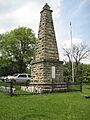
Beyond homes and barns, other types of sites hold historical significance.
- The Kellogg's Grove southeast of Kent, listed in 1978, is an important historical site. It played a role in the Black Hawk War in 1832.
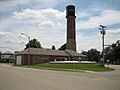
- The Lena Water Tower in Lena, added in 1997, is an interesting example of historic infrastructure. Water towers are vital for providing water to a town.
- The Soldiers' Monument in Freeport, listed in 1998, is a memorial dedicated to soldiers, often from past wars, honoring their service and sacrifice.
- The Oscar Taylor House in Freeport, listed in 1984, is another significant historic home in the area.
Images for kids
-
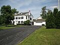
The John H. Addams Homestead in Cedarville.
-
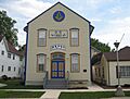
The AF and AM Lodge 687 in Orangeville.
-
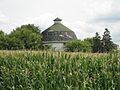
The James Bruce Round Barn near Freeport.
-
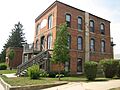
The Central House in Orangeville.
-
The Charles Fehr Round Barn near Orangeville.
-
Freeport City Hall.
-
The Gerald Harbach Round Barn near Eleroy.
-
Kellogg's Grove near Kent.
-
The Lena Water Tower.
-
The Dennis Otte Round Barn near Eleroy.
-
The People's State Bank in Orangeville.
-
The William Ritzman House in Orangeville.
-
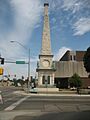
The Soldiers' Monument in Freeport.
-
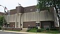
The current Stephenson County Courthouse, built on the site of the original historic courthouse.
-
The Oscar Taylor House in Freeport.
-
The Union House in Orangeville.


