
National Register of Historic Places listings in Union Parish, Louisiana facts for kids

Have you ever wondered about old buildings and places that are super important to history? In Union Parish, Louisiana, there are special spots that are officially recognized for their historical value! These places are listed on the National Register of Historic Places. It's like a special club for buildings, churches, and monuments that tell us about the past.
When a place is on this list, it means it's worth protecting and remembering. It helps people learn about the history of Louisiana and the United States. You can even see where these places are on a map if you know their exact location! Union Parish has 11 of these amazing historic places.
Contents
Exploring Historic Places in Union Parish
Union Parish is home to several fascinating places that have been around for a long time and hold many stories. Let's take a look at some of them!
Historic Buildings in Bernice
The town of Bernice has a few buildings that are important to its history.
- Alabama Methodist Church: This old church was added to the list in 1995. It's located on Alternate Louisiana Highway 2 and has been a part of the community for many years.
- Bernice Civic Clubhouse: This building, listed in 1994, is on Louisiana Highway 2. It likely served as a gathering place for people in Bernice.
- Garland House: Found at 701 Cherry Street, the Garland House became historic in 1994. It's a great example of an old home in the area.
- J.W. Heard House: Right near the Garland House at 605 Cherry Street, the J.W. Heard House was also listed in 1994. These houses show us what homes looked like long ago.
- Lindsey Bonded Warehouses: These warehouses on Holly and 2nd Streets were added to the list in 1999. Warehouses are important for storing goods and show how towns grew through trade.
- R.T. Moore House: This house, listed in 1994, is on the northern side of Alternate Louisiana Highway 2. It's another example of the historic homes in the Bernice area.
Historic Spots in Farmerville
Farmerville, the parish seat of Union Parish, also has its share of historic buildings.
- Edgewood: This property, listed in 1980, is located west of Farmerville on the Bernice Highway. It's an important historical site in the area.
- Daniel Stein House: At 208 West Bayou, the Daniel Stein House was recognized in 1988. It's a significant old home in Farmerville.
- Dr. Terral Clinic: This clinic at 107 North Washington Street was added to the list in 1999. It reminds us of how healthcare was provided in the past.
Historic Places in Marion
The town of Marion also has some interesting historical sites.
- Dual State Monument: This unique monument, listed in 2000, is on Union County Road 86. What makes it special is that it actually extends into Union County, Arkansas! It marks the border between the two states.
- Hopkins House: Located on Hopkins Lane, the Hopkins House was added to the list in 1983. It's another important historic home in the Marion area.
Images for kids
-
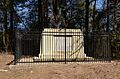
The Dual State Monument, marking the border between Louisiana and Arkansas.

