
National Register of Historic Places listings in Wicomico County, Maryland facts for kids

Did you know that many special places in the United States are protected because of their history? These places are listed on the National Register of Historic Places. It's like a national scrapbook of important buildings, sites, and objects that tell us about the past. In Wicomico County, Maryland, there are 23 amazing places that have been added to this list!
These historic spots are found all over Wicomico County, from old churches to grand homes and even a former train station. Each one has a unique story to tell about how people lived, worked, and built communities in Maryland long ago. Let's explore some of these cool historic places!
Contents
Historic Places in Wicomico County
Allen, Maryland
- Asbury Methodist Episcopal Church: This church was listed in 1999. It's a historic church building located in Allen.
- Bennett's Adventure: This historic home was added to the list in 1975. It's found west of Allen.
- Bounds Lott: Listed in 1978, Bounds Lott is another important historic property in Allen.
Bivalve, Maryland
- Yellow Brick House: This unique house, listed in 1978, stands out with its yellow bricks in Bivalve.
Hebron, Maryland
- Maple Leaf Farm Potato House: Listed in 1998, this building was once used to store potatoes, which was a big crop in the area.
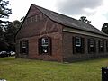
- Spring Hill Church: This church was listed in 1976. Sadly, it was destroyed by fire in 2014, but its history is still remembered.
- St. Giles: This historic property, located southwest of Hebron, was added to the list in 1982.
- Western Fields: Listed in 1987, Western Fields is another historic site near Hebron.
Quantico, Maryland
- St. Bartholomew's Episcopal Church: This beautiful church was listed in 1975. It's a significant religious building in Quantico.
Salisbury, Maryland
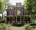
- Gillis-Grier House: This historic house in Salisbury was listed in 1972.
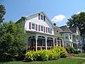
- Honeysuckle Lodge: Added to the list in 1996, Honeysuckle Lodge is another interesting historic home in Salisbury.
- Sen. William P. Jackson House: This house, once owned by Senator William P. Jackson, was listed in 1976. It was later taken down in the same year.
- Pemberton Hall: Listed in 1971, Pemberton Hall is a very old and important building in Salisbury.
- Perry-Cooper House: This house was added to the National Register in 1977.
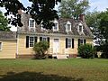
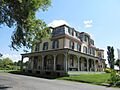
- Poplar Hill Mansion: Listed in 1971, Poplar Hill Mansion is a grand historic home in Salisbury.
- Union Station: This building was once a busy train station in Salisbury. It was listed in 2007.
- United States Post Office (Maude R. Toulson Federal Building): Originally a post office, this building was listed in 2016 and is now known as the Maude R. Toulson Federal Building.
- F. Leonard Wailes Law Office: This historic law office building was listed in 1997.
Sharptown, Maryland
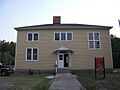
- San Domingo School: This historic school building in Sharptown was listed in 2007. It tells a story about education in the past.
Tyaskin, Maryland
- Beaudley: This historic property in Tyaskin was added to the list in 2001.
Wetipquin, Maryland
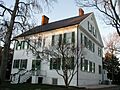
- Long Hill: Listed in 1974, Long Hill is a historic site located in Wetipquin.
Whitehaven, Maryland
- Whitehaven Historic District: This isn't just one building, but a whole area! The Whitehaven Historic District was listed in 1980 because it has many historic buildings that together show what the town was like long ago.
- Whitehaven Hotel: This historic hotel, located within the Whitehaven Historic District, was listed in 1996.
Images for kids
-
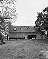
Bounds Lott
-
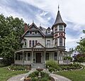
Gillis-Grier House
-
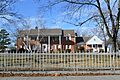
Site of the former Sen. William P. Jackson House
-
Long Hill
-

Pemberton Hall
-
Perry-Cooper House
-
Poplar Hill Mansion
-
San Domingo School
-

Spring Hill Church (before it was destroyed)
-
St. Bartholomew's Episcopal Church
-
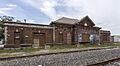
Union Station
-
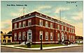
United States Post Office (now Maude R. Toulson Federal Building)
-

F. Leonard Wailes Law Office
-
Whitehaven Historic District
-
Whitehaven Hotel


.jpg)
_from_SSW_1.JPG)


.jpg)


.jpg)
_4.JPG)


