Naul Hills facts for kids
Quick facts for kids Naul Hills |
|
|---|---|

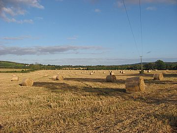
View from Flemingtown, Co. Meath, towards the Naul Hills, with Knockbrack to the right
|
|
| Highest point | |
| Elevation | 176 m (577 ft) |
| Naming | |
| Language of name | English |
| Geography | |
| Location | Fingal, Ireland |
| Parent range | Naul Hills |
| OSI/OSNI grid | O133602 |
| Topo map | OSI Discovery 43 |
| Climbing | |
| Easiest route | West from M1 on R122, then south on R108. |
The Naul Hills, also known as the Man-of-War Hills, are a group of small hills in Fingal, Ireland. They are located very close to the village of Naul. This village was once called The Naul. Its name comes from the Irish phrase An Aill, which means 'the cliff'.
These hills are found right beside the County Meath border. They are about 30 kilometers north of Dublin City. This is also about 17 kilometers north of Dublin Airport. The Naul Hills are 16 kilometers north-northwest of Swords and 8 kilometers southwest of Balbriggan.
Exploring the Naul Hills
How High Are the Hills?
Most of the hills in the Naul area are between 140 and 150 meters high. To give you an idea, that's roughly the height of a 45-story building! The very highest point in this area is a hill called Knockbrack. Knockbrack stands at 176 meters tall. Its name, An Cnoc Breac in Irish, means 'the speckled hill'.
What Are the Hills Made Of?
For many years, people have been digging for limestone in the Naul Hills. This process is called quarrying. Limestone is a type of rock used in building and making cement. Back in 1829, a book called the London Encyclopaedia mentioned something interesting. It said that there was coal in Naul. However, the book also noted that this coal was not being dug up or used.
 | William Lucy |
 | Charles Hayes |
 | Cleveland Robinson |


