Nienburg (district) facts for kids
Quick facts for kids
Nienburg
|
||
|---|---|---|
|
||
| Country | ||
| State | Lower Saxony | |
| Capital | Nienburg | |
| Area | ||
| • Total | 1,399 km2 (540 sq mi) | |
| Population
(2001)
|
||
| • Total | 126,300 | |
| • Density | 90.28/km2 (233.82/sq mi) | |
| Time zone | UTC+1 (CET) | |
| • Summer (DST) | UTC+2 (CEST) | |
| Vehicle registration | NI | |
| Website | landkreis-nienburgweser.de | |
Nienburg is a district, also known as a Landkreis, located in Lower Saxony, Germany. It's a region where many towns and villages come together to work as one larger area. The main town and capital of this district is also called Nienburg.
Contents
About Nienburg District
The Nienburg district is a part of Germany called Lower Saxony. It covers an area of about 1,399 square kilometers (which is about 540 square miles). Imagine an area roughly the size of a thousand football fields! In 2001, about 126,300 people lived here. This means there were about 90 people living in each square kilometer.
What is a District?
In Germany, a district (or Landkreis) is like a county in some other countries. It's a way to organize different towns and villages into a bigger administrative area. This helps with things like schools, roads, and other public services that benefit everyone in the region. The district government helps manage these services for all the people living there.
Towns and Villages in Nienburg
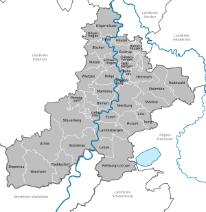
The Nienburg district is made up of several towns and many smaller communities. These communities are grouped together into what are called Samtgemeinden, which are like groups of villages that share some services.
Here are the main towns:
- Nienburg (which is also the capital)
- Rehburg-Loccum
There is also one main "free municipality" which means it manages itself without being part of a Samtgemeinde:
- Steyerberg
The rest of the communities are part of seven Samtgemeinden:
- 1. Grafschaft Hoya
- Bücken
- Eystrup
- Gandesbergen
- Hämelhausen
- Hassel
- Hilgermissen
- Hoya (This is the main town of this group)
- Hoyerhagen
- Schweringen
- Warpe
- 2. Heemsen
- Drakenburg
- Haßbergen
- Heemsen
- Rohrsen (Main town of this group)
- 3. Liebenau
- Binnen
- Liebenau (Main town of this group)
- Pennigsehl
- 4. Marklohe
- Balge
- Marklohe (Main town of this group)
- Wietzen
- 5. Mittelweser
- Estorf
- Husum
- Landesbergen
- Leese
- Stolzenau (Main town of this group)
- 6. Steimbke
- Linsburg
- Rodewald
- Steimbke (Main town of this group)
- Stöckse
- 7. Uchte
- Diepenau
- Raddestorf
- Uchte (Main town of this group)
- Warmsen
Where is Nienburg?
The Nienburg district is located in the northern part of Germany. It's part of the state of Lower Saxony. You can find it by looking for its coordinates: 52.67 degrees North and 9.17 degrees East. This helps pinpoint its exact location on a map of the world.
See also
 In Spanish: Distrito de Nienburg-Weser para niños


