
Northumberland Islands facts for kids
|
Native name:
Nu Tannik Ckelo
|
|
|---|---|

Northumberland Islands
Location in Australia
|
|
| Geography | |
| Location | Coral Sea |
| Coordinates | 21°30′S 149°40′E / 21.500°S 149.667°E |
| Archipelago | Northumberland Isles |
| Administration | |
|
Australia
|
|
| State | Queensland |
| Demographics | |
| Population | 150 (Tourism) |
The Northumberland Islands are a group of islands found off the eastern coast of Queensland, Australia. They are spread out across the Coral Sea. These islands are a popular spot for tourism, with about 150 people visiting them.
Contents
Exploring the Northumberland Islands
The Northumberland Islands are located to the south-east of the city of Mackay. They lie between 21°S and 22°S latitude. All the islands are "continental type," meaning they were once part of the mainland.
The famous explorer James Cook named this island group in 1770. He was on his important journey along Australia's eastern coast. He named them after Hugh Percy, who was the First Duke of Northumberland. Another explorer, Matthew Flinders, also wrote about these islands in his travel journals.
Cook described the islands as being "scatter'd up and down in this bay in great number." He noted that they were "various in their height and circuit as they are numerous." This means the islands came in many different sizes and shapes.
These islands are quite remote, which means they are far away and hard to reach. You can usually only get there by private yacht. However, there are also special charter flights to Marble Island.
Island Groups and Their Names
The Northumberland Islands are divided into several smaller groups. Each group has its own unique name and history. Below are the main islands in each group, along with their geographical coordinates.
Bedwell Group
This group is named after Staff Commander E. P. Bedwell, who was a surveyor.
- Calliope Island
- Connor Islet
- Innes Island
- George Island
- Poynter Island 21°50′S 149°47′E / 21.833°S 149.783°E
Beverley Group
The origin of this group's name is not known.
- Beverlac Island
- Digby Island 21°30′S 149°56′E / 21.500°S 149.933°E
- Double Island
- Henderson Island
- Hull Island
- Keelan Island
- Knight Island
- Minster Island
- Noel Island
- Prudhoe Island 21°19′S 149°41′E / 21.317°S 149.683°E
Broad Sound Islands
These islands are located at the mouth of Broad Sound. This large inlet was named by Captain Cook in 1770.
- Long Island 22°10′S 149°53′E / 22.167°S 149.883°E
- Quail Island22°08′S 149°59′E / 22.133°S 149.983°E
- Tern Island
- Wild Duck Island 22°01′S 149°52′E / 22.017°S 149.867°E
Duke Islands
The reason for the name of this group is unknown.
- Alnwick Island
- Bamborough Island
- Cheviot Island
- Hexham Island 22°02′S 150°22′E / 22.033°S 150.367°E
- High Peak Island 21°57′S 150°41′E / 21.950°S 150.683°E
- Hunter Island
- Marble Island 21°59′S 150°11′E / 21.983°S 150.183°E
- Otterbourne Island
- Shields Island
- Steep Island
- Tweed Island
- Tynemouth Island
Flat Isles
Matthew Flinders named these islands in 1802 because they are not very high. Avoid Island is the tallest at 33 meters above sea level.
- Aquila Island 21°58′S 149°33′E / 21.967°S 149.550°E
- Avoid Island
- Flock Pigeon Island 22°08′S 149°34′E / 22.133°S 149.567°E
- Red Clay Island
Guardfish Cluster
The origin of this group's name is not known.
- Bluff Island
- Curlew Island 21°37′S 149°48′E / 21.617°S 149.800°E
- Tinonee Peak Island
Percy Isles
Flinders named these islands in 1802. He named them after the family name of the Duke of Northumberland.
- Hotspur Island
- Shrewsbury Rock
- Middle Percy Island 21°39′S 150°16′E / 21.650°S 150.267°E
- North East Island
- Pine Islet
- Pine Peak Island
- South Percy Island21°46′S 150°20′E / 21.767°S 150.333°E
- Sphinx Island
- Walter Island
Images for kids
-
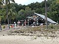
A Frame yacht club on Middle Percy Island (Percy Isles)
-

Western side of Hunter Island looking toward Tynemouth Island (Duke Islands)


