
Okrouhlička facts for kids
Quick facts for kids
Okrouhlička
|
|
|---|---|
|
Municipality
|
|
.jpg)
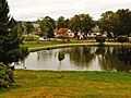
Centre of Okrouhlička
|
|

Okrouhlička
Location in Czech Republic
|
|
| Country | |
| Region | Vysočina |
| District | Havlíčkův Brod |
| First mentioned | 1307 |
| Area | |
| • Total | 6.85 km2 (2.64 sq mi) |
| Elevation | 478 m (1,568 ft) |
| Population
(2024-01-01)
|
|
| • Total | 282 |
| • Density | 41.17/km2 (106.62/sq mi) |
| Time zone | UTC+1 (CET) |
| • Summer (DST) | UTC+2 (CEST) |
| Postal code |
582 53
|
Okrouhlička is a small municipality and village in the Czech Republic. It is located in the Vysočina Region, within the Havlíčkův Brod District. This charming village is home to around 300 people. Before 1945, it was known as Šejdorf.
Contents
About Okrouhlička
Okrouhlička is a quiet place in the Czech countryside. It is known for its peaceful atmosphere. The village is part of the larger Havlíčkův Brod District.
Village Parts
The village of Skřivánek is an important part of Okrouhlička. It is considered an administrative section of the municipality.
Village History
The first time Okrouhlička was mentioned in writing was in the year 1307. This means the village has a long history, dating back over 700 years.
Population Changes
The number of people living in Okrouhlička has changed over time. This is called demographics. Looking at the population numbers helps us understand how the village has grown or shrunk.
| Historical population | ||
|---|---|---|
| Year | Pop. | ±% |
| 1869 | 446 | — |
| 1880 | 507 | +13.7% |
| 1890 | 525 | +3.6% |
| 1900 | 479 | −8.8% |
| 1910 | 491 | +2.5% |
| 1921 | 468 | −4.7% |
| 1930 | 400 | −14.5% |
| 1950 | 296 | −26.0% |
| 1961 | 289 | −2.4% |
| 1970 | 253 | −12.5% |
| 1980 | 260 | +2.8% |
| 1991 | 214 | −17.7% |
| 2001 | 194 | −9.3% |
| 2011 | 225 | +16.0% |
| 2021 | 274 | +21.8% |
| Source: Censuses | ||
As you can see from the table, the population was higher in the late 1800s. It then decreased for many years. Recently, the number of people living in Okrouhlička has started to grow again.
Images for kids
-
Centre of Okrouhlička
See also
 In Spanish: Okrouhlička para niños
