Paerata railway station facts for kids
Quick facts for kids
Paerata railway station
|
||||||||||||||||
|---|---|---|---|---|---|---|---|---|---|---|---|---|---|---|---|---|

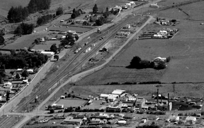
Paerata in 1962
|
||||||||||||||||
| Location | New Zealand | |||||||||||||||
| Coordinates | 37°10′03″S 174°53′46″E / 37.167362°S 174.896078°E | |||||||||||||||
| Elevation | 45 m (148 ft) | |||||||||||||||
| Line(s) | North Island Main Trunk | |||||||||||||||
| Distance | Wellington 632.35 km (392.92 mi) | |||||||||||||||
| History | ||||||||||||||||
| Opened | 20 May 1875 | |||||||||||||||
| Closed | 1 October 1982 | |||||||||||||||
| Services | ||||||||||||||||
|
||||||||||||||||
Paerata railway station was a train stop in New Zealand. It was located about 28 mi (45 km) south of Auckland. This station was part of the important North Island Main Trunk railway line. It served the small community of Paerata.
The station first opened its doors on 20 May 1875. It stopped serving passengers on 24 July 1972. The station then closed completely for all train traffic on 1 October 1982. However, a special section of track called a crossing loop remained. This loop allowed trains to pass each other.
In 1981, the railway junction at Paerata was updated. This junction connected to the Waiuku Branch line. New signals were added, and a new connection was built towards Pukekohe.
Contents
What Was Paerata Station Like?
The railway line reached Paerata in 1873. The full line to Mercer opened on 20 May 1875. A small building was put up in 1874. By 1884, the station had a shelter shed. It also had a passing loop for 22 wagons. This loop allowed trains to wait while others passed.
How Paerata Station Grew
By 1896, Paerata station had a passenger platform. It also had a way for carts to reach it. The passing loop was made longer for 28 wagons. Later, sheep yards and a loading area were added. From 1906, the station staff even ran a Post Office. This Post Office moved to a local store in 1923.
To prepare for the Waiuku Branch line, the loop was made even longer in 1913. It could then hold 70 wagons. Two small houses and a goods shed were built in 1914. In 1917, the station got an island platform. This means the platform was in the middle of two tracks.
Changes to the Tracks
Between 1914 and 1916, the steepness of the Karaka bank was reduced. This was a section of track between Runciman and Paerata. The work involved digging large cuttings and building up embankments. A cutting about 1 mi (1.6 km) north of Paerata had problems with slips. These were small landslides. One slip in 1916 meant the track had to be temporarily moved. A new passing loop was also added at Karaka. This was about 4.74 km (2.95 mi) north of Paerata.
Paerata Becomes a Junction
Paerata became a junction station on 10 December 1917. This was when the first part of the Waiuku Branch line opened. It went as far as Patumahoe. In 1922, trains on this branch line ran only twice a week. They ran once each way on Tuesdays and Fridays. In 1926, modern automatic signals replaced older "token blocks." These old systems used metal tokens to control train movements. In 1928, 35 wagons came off the tracks between Pukekohe and Paerata.
Upgrades and Final Closure
The railway line between Papakura and Paerata was made into two tracks. This was finished by 3 December 1939. The double track then reached Pukekohe in 1941. From 1923 until at least 1943, a local dairy factory had its own private railway siding. This allowed goods to be loaded directly.
On 24 July 1972, Paerata stopped handling all goods. It only accepted full wagon loads. The animal stockyards were removed. The goods shed was moved to another railway depot in 1973. In 1978, the goods shed loop was sold to the Glenbrook Vintage Railway. The station officially closed to all traffic on 17 July 1977. By 1982, the station building itself had been taken down.
A New Paerata Station?
There are plans for new train stations in the area. These include new stations for Drury West and Paerata. A proposal for this was made in July 2017. It is part of a $600 million plan for Auckland's transport. This money would help support new homes being built.
The new stations will be built by a group called Crown Infrastructure Partners. This is because the Auckland Council has reached its borrowing limit. The new Paerata station would be located just east of Paerata Rise. This is about 1 km (0.62 mi) south of where the old station used to be.
 | Bessie Coleman |
 | Spann Watson |
 | Jill E. Brown |
 | Sherman W. White |

