
Palk Strait facts for kids


The Palk Strait is a narrow stretch of water that separates India and Sri Lanka. It lies between the state of Tamil Nadu in India and the Mannar district in Sri Lanka. This strait connects the Bay of Bengal to the northeast with Palk Bay and then with the Gulf of Mannar to the southwest.
The Palk Strait is about 33 to 50 miles (53 to 80 kilometers) wide. Several rivers flow into it, including the Vaigai River from Tamil Nadu. The strait is named after Robert Palk. He was a governor of the Madras Presidency from 1755 to 1763, during the time when the British East India Company ruled parts of India.
Geography of Palk Strait
At the southern end of the Palk Strait, there is a chain of low islands and sandy areas called Adam's Bridge. This chain stretches between Dhanushkodi on Pamban Island in India and Mannar Island in Sri Lanka.
The waters in the Palk Strait are quite shallow. Also, there are many reefs, which are like underwater rocky areas. Because of these shallow waters and reefs, it is very hard for large ships to travel through the strait.
Images for kids
-
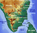
A map showing the Gulf of Mannar near the Palk Strait.

See also
 In Spanish: Estrecho de Palk para niños
