Palmichal facts for kids
Quick facts for kids
Palmichal
|
|
|---|---|
|
District
|
|

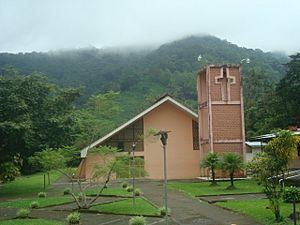
Palmichal Church, Acosta, Costa Rica
|
|
| Country | |
| Province | San José |
| Canton | Acosta |
| Area | |
| • Total | 34.17 km2 (13.19 sq mi) |
| Elevation | 1,097 m (3,599 ft) |
| Population
(2011)
|
|
| • Total | 4,581 |
| • Density | 134.06/km2 (347.23/sq mi) |
| Time zone | UTC−06:00 |
| Postal code |
11203
|
Palmichal is a special area, like a neighborhood, within the Acosta canton. A canton is similar to a county. Palmichal is located in the San José province of Costa Rica.
Contents
Geography of Palmichal
Palmichal covers an area of about 34.17 square kilometers (13.2 square miles). It sits high up, about 1,097 meters (3,599 feet) above sea level.
Rivers and Nature
The Tabarcia River starts in the mountains near San Pablo town, which is part of Palmichal. This river is important because it flows into the larger Parrita River system.
The natural springs in San Pablo are a popular spot for visitors. You can also see many coffee and citrus farms around Palmichal.
People of Palmichal
| Historical population | |||
|---|---|---|---|
| Census | Pop. | %± | |
| 1892 | 227 | — | |
| 1927 | 1,102 | 385.5% | |
| 1950 | 1,886 | 71.1% | |
| 1963 | 2,536 | 34.5% | |
| 1973 | 2,270 | −10.5% | |
| 1984 | 2,691 | 18.5% | |
| 2000 | 3,852 | 43.1% | |
| 2011 | 4,581 | 18.9% | |
|
Instituto Nacional de Estadística y Censos |
|||
In 2011, a census showed that about 4,581 people lived in Palmichal. A census is like a big count of everyone living in an area.
Getting Around Palmichal
Road Connections
The main road that goes through Palmichal is:
- National Route 209
See also
 In Spanish: Palmichal para niños


