Palmito, Sucre facts for kids
Quick facts for kids
Palmito, Sucre
|
||
|---|---|---|
|
Municipality and town
|
||
|
||

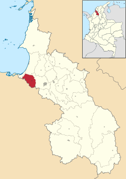
Location of the municipality and town of Palmito, Sucre in the Sucre Department of Colombia.
|
||
| Country | ||
| Department | Sucre Department | |
| Area | ||
| • Municipality and town | 176 km2 (68 sq mi) | |
| Elevation | 3 m (10 ft) | |
| Population
(2015)
|
||
| • Municipality and town | 13,682 | |
| • Density | 77.74/km2 (201.3/sq mi) | |
| • Urban | 5,345 | |
| Time zone | UTC-5 (Colombia Standard Time) | |
Palmito, officially known as San Antonio de Palmito, is a small town and a special area called a municipality. It is located in the Sucre Department in northern Colombia. This town is an important part of the Sucre region.
Contents
What is Palmito, Sucre?
Palmito is a municipality, which is like a local government area, in Colombia. It includes both the main town and the surrounding rural areas. The official name, San Antonio de Palmito, honors Saint Anthony.
Where is Palmito located?
Palmito is found in the northern part of Colombia. It is part of the Sucre Department, which is one of the many departments (like states) in Colombia. Its location is close to the Caribbean coast.
How big is Palmito?
The total area of Palmito is about 176 square kilometers. This makes it a relatively small municipality. In 2015, about 13,682 people lived there. Most of these people live in the main town, while others live in the countryside.
What is the weather like in Palmito?
Palmito has a tropical climate. This means it is usually warm all year round. The town is only about 3 meters above sea level. This low elevation contributes to its warm temperatures.
See also
 In Spanish: San Antonio de Palmito para niños
 | Bessie Coleman |
 | Spann Watson |
 | Jill E. Brown |
 | Sherman W. White |


