Pelican Lake (Manitoba) facts for kids
Quick facts for kids Pelican Lake |
|
|---|---|
 |
|
| Location | Manitoba, Canada |
| Coordinates | 49°20′09″N 99°33′49″W / 49.33583°N 99.56361°W |
| Primary inflows | Orthez drain |
| Catchment area | 686 km2 (265 sq mi) |
| Managing agency | Pelican Lake Regulation Project |
| Max. length | 11 mi (18 km) |
| Max. width | 1 mi (1.6 km) |
| Surface area | 10.8 sq mi (28 km2) |
| Average depth | 3.8 m (12 ft) |
| Max. depth | 5.2 m (17 ft) |
| Water volume | 108,000,000,000 liters (2.4×10¹⁰ imp gal; 2.9×10¹⁰ U.S. gal) |
| Surface elevation | 412.0 m (1,351.7 ft) |
| Settlements | Ninette |
Pelican Lake is the biggest lake you can navigate in southwestern Manitoba, Canada. It's about 11 miles (18 km) long and 1 mile (1.6 km) wide. The lake covers an area of about 10.8 square miles (27.8 square kilometers).
This lake is quite shallow. Its average depth is 3.8 meters (12.5 feet), and its deepest point is 5.2 meters (17 feet). When the water level is at 412.0 meters (1351.7 feet), the lake holds an amazing 108 billion liters of water! Small waterways feed into the lake, with the Orthez drain being the main one.
Pelican Lake has been a popular spot for fun and relaxation for over a hundred years. People started visiting by train in the early 1900s. Today, it's still a favorite place for boating, sailing, fishing, and many other water sports. Many people also own cottages or homes around the lake.
The town of Ninette is located at the north end of Pelican Lake. It's less than an hour's drive from Brandon and about two hours from Winnipeg. The lake is part of the Rural Municipalities of Killarney-Turtle Mountain and Prairie Lakes.
Contents
How Pelican Lake's Water Levels Are Managed
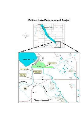
The Pelican Lake Regulation Project was built between 1990 and 1992. Its main goal is to control the water levels in Pelican Lake. This project helps keep the lake from getting too high or too low.
Moving Water In and Out
The project uses special channels and structures to move water.
- When the lake's water level is low, water can be brought in from the Pembina River.
- When the lake's water level is high, water can be released from the lake into the Pembina River.
These operations are managed by Manitoba Infrastructure and Transportation. They follow specific rules to make sure the lake stays at a good level. A group called the Pelican Lake Advisory Committee also gives advice on how to operate these water controls.
Keeping the Lake at the Right Level
During the summer, the lake is usually kept between 411.5 meters (1350.2 feet) and 412 meters (1351.7 feet) above sea level. Sometimes in the spring, the water level might go up a little higher, to about 412.2 meters (1352.4 feet).
When the lake needs more water, it can take up to 9 cubic meters (320 cubic feet) of water per second from the Pembina River. However, water isn't diverted into the lake if the Pembina River's flow is too low. Also, diversions don't start in spring until nearby Lorne and Louise lakes are full.
If the lake has too much water, it can release about 11 cubic meters (390 cubic feet) of water per second into the Pembina River. This helps prevent flooding.
How Water Diversions Affect the Lake
If water is brought into the lake at full speed for one day, the lake level goes up by about 1.2 inches (3 cm). If water is released from the lake at full speed for one day, the lake level goes down by about 1.5 inches (3.8 cm). These calculations assume no new water flows into the lake and that the Pembina River can handle the outflow.
In reality, a lot of water usually flows into Pelican Lake each year. Also, releasing water from Pelican Lake is sometimes limited if the Pembina River is already very high.
The project was first built to help raise the lake level when it was very low in 1991. But it became even more important from 1995 to 2017. During this time, the area had a lot of rain. The project helped divert a huge amount of water out of the lake. This prevented serious flooding in many of those years. For example, from 1962 to 1994, the average amount of water flowing into the lake each year was about 6.5 inches (16.5 cm). But from 1995 to 2017, it jumped to 32.6 inches (82.8 cm) per year! The regulation project was very helpful in managing these higher water levels.
 | James Van Der Zee |
 | Alma Thomas |
 | Ellis Wilson |
 | Margaret Taylor-Burroughs |


