Pentre Camp facts for kids

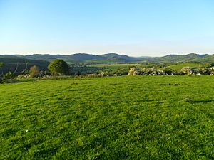
View from the fort, looking north-east
|
|
| Location | Near Llangynyw, Wales |
|---|---|
| Coordinates | 52°40′36″N 3°18′24″W / 52.67667°N 3.30667°W |
| Type | Hillfort |
| Length | 74 metres (243 ft) |
| Width | 48 metres (157 ft) |
| Area | 0.8 acres (0.32 ha) |
| History | |
| Periods | Iron Age |
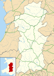
Pentre Camp is an ancient hillfort from the Iron Age period. It is located near the small village of Llangynyw in Powys, Wales. This historic site is about 2.5 miles (4 km) north-east of Llanfair Caereinion. Pentre Camp is officially protected as a scheduled monument, which means it's an important historical place.
What is Pentre Camp?
Pentre Camp is shaped like an oval. It measures about 74 metres (243 ft) long and 48 metres (157 ft) wide. The total area inside the fort is about 0.8 acres (0.32 ha).
Fort Walls and Entrances
This hillfort has several layers of defensive walls, called ramparts.
- In the northern and western parts, there are three ramparts.
- In other areas, there are as many as five ramparts.
- You can also see hints of even more ramparts in the southern and western parts of the fort.
All these walls are quite low now. Experts think they might have been low from the start, acting as strong foundations for wooden fences or walls that stood on top of them.
In the eastern part of the fort, the third and fourth ramparts connect to form a special entrance passage. This would have been the main way in and out of the fort.
Water Supply for the Fort
A short distance from the fort, at the bottom of its northern slope, there is a natural spring. This spring still provides water today. Having a reliable water source nearby was very important for people living in the fort a long time ago. It likely played a big part in why this spot was chosen for the hillfort.
 | Leon Lynch |
 | Milton P. Webster |
 | Ferdinand Smith |


