Pershing, Wisconsin facts for kids
Quick facts for kids
Pershing, Wisconsin
|
|
|---|---|

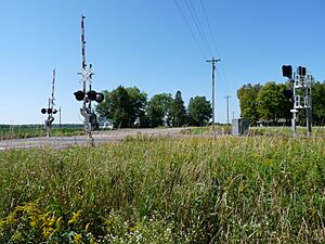
Donald, where the Soo Line met the Omaha Railroad and CTH M. Most of Pershing is flat like this area.
|
|

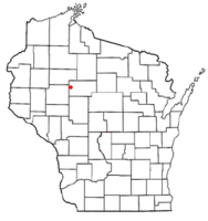
Location of Pershing, Wisconsin
|
|
| Country | |
| State | |
| County | Taylor |
| Area | |
| • Total | 35.8 sq mi (92.8 km2) |
| • Land | 35.7 sq mi (92.4 km2) |
| • Water | 0.2 sq mi (0.4 km2) |
| Elevation | 1,188 ft (362 m) |
| Population
(2000)
|
|
| • Total | 180 |
| • Density | 5.0/sq mi (1.9/km2) |
| Time zone | UTC-6 (Central (CST)) |
| • Summer (DST) | UTC-5 (CDT) |
| Area code(s) | 715 & 534 |
| FIPS code | 55-62100 |
| GNIS feature ID | 1583911 |
| PLSS township | T32N R4W |
Pershing is a small town located in Taylor County, Wisconsin, in the United States. According to the 2000 census, about 180 people lived there. The tiny community of Donald is also part of Pershing.
Contents
Geography of Pershing
Pershing covers an area of about 35.8 square miles (92.8 square kilometers). Most of this area, about 35.7 square miles (92.4 square kilometers), is land. The rest, a small part of 0.2 square miles (0.4 square kilometers), is water.
The water areas in Pershing are mainly:
- Man-made flowages (areas where water is held back) in the Pershing Wildlife Area.
- The Fisher River, which flows through Pershing from east to west.
History of Pershing
Early Surveys and Land Description
The land that became Pershing was first mapped in 1847 by the U.S. government. Another survey happened in 1852. In 1855, a team walked through the woods and swamps to mark all the land corners. They used chains and compasses to measure everything.
After their work, the surveyor described the area: "This Township contains several swamps... They are all unfit for cultivation. The meadow and Alder bottoms are all subject to be overflowed... The surface is generally low and level... This township is heavily timbered and is chiefly composed of Hemlock and Yellow Birch on low level land and on uplands Sugar Maple, Linden, White Pine and Balsam. There is no improvements on this Township."
This means the land was mostly flat, wet in places, and covered with many trees like hemlock, birch, maple, and pine. There were no buildings or farms yet.
Logging and Railroads
Logging, which is cutting down trees for wood, started in Pershing in the late 1800s. Around 1903, the Eau Claire, Chippewa Falls, and Northeastern Railway (also called the Omaha) built its train tracks across the area. These tracks ran just south of where County Highway M is today.
Then, around 1905, the Wisconsin Central Railway built another set of tracks. These tracks later became part of the Soo Line, and trains still use them today. Where these two train lines met, the community of Donald began to grow.
Settlement and Farming
By 1911, maps showed the two railroads in Pershing. Most of the land was still owned by logging companies. There were no homes for settlers yet. However, by 1913, a few settlers started to build homes, mostly along the roads that would become County Highways M and H. This marked the beginning of a change from logging to farming in the area.
As more trees were cut down and the best timber ran out, farming became more important. The Omaha railroad closed in 1939. In August 1936, a large part of Pershing (more than two-thirds) was burned by wildfires, forcing fifteen families to leave their homes.
Pershing Wildlife Area
The Pershing Wildlife Area was created in 1953. At first, Taylor County leased some land to the state for public hunting. In 1960, the county gave 3,400 acres of land to the state. Since then, the DNR has managed this area.
Today, the wildlife area is about 7,900 acres. Much of it is wetlands, which are wet, marshy areas. These wetlands have been improved with man-made flowages and small ponds. The area is managed to help animals like waterfowl (ducks, geese) and sharp-tailed grouse thrive.
Pershing Today
As of 2023, Donald is almost a ghost town, with only a few houses left. Canadian National trains still pass through, but they don't stop. Much of Pershing is now used for farming, with families raising dairy cows, beef cattle, and growing crops.
Population and People
As of the 2000 census, there were 180 people living in Pershing. These people lived in 70 households, and 45 of these were families. The town had about 5 people per square mile.
The people living in Pershing were all identified as White. A very small number, about 0.56%, were of Hispanic or Latino background.
- About 28.6% of households had children under 18 living with them.
- Half of the households (50.0%) were married couples living together.
- About 14.3% of households had someone living alone who was 65 years old or older.
The average household had about 2.57 people, and the average family had about 3.22 people. The median age in Pershing was 41 years old.
See also
 In Spanish: Pershing (Wisconsin) para niños
 | Audre Lorde |
 | John Berry Meachum |
 | Ferdinand Lee Barnett |

