Piendamó, Cauca facts for kids
Quick facts for kids
Piendamó
|
|||
|---|---|---|---|
|
Municipality and town
|
|||

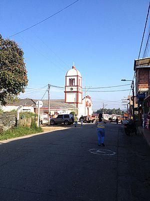
Church of Piendamó
|
|||
|
|||

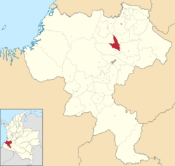
Location of Piendamó in Cauca
|
|||
| Country | |||
| Department | Cauca | ||
| Province | Central | ||
| Founded | 2 April 1924 | ||
| Founded by | Pedro Antonio Sandoval | ||
| Area | |||
| • Municipality and town | 197 km2 (76 sq mi) | ||
| • Urban | 30 km2 (10 sq mi) | ||
| Elevation | 1,685 m (5,528 ft) | ||
| Population
(2017)
|
|||
| • Municipality and town | 44,535 | ||
| • Density | 226.1/km2 (585.5/sq mi) | ||
| • Urban | 14,696 | ||
| • Urban density | 490/km2 (1,270/sq mi) | ||
| Time zone | UTC-5 (Colombia Standard Time) | ||
| Climate | Cfb | ||
Piendamó is a town and a municipality (like a county) in the southwestern part of Colombia. It is located in the Cauca region. As of 2017, about 44,535 people live there.
Contents
History of Piendamó
The town of Piendamó was officially founded by Pedro Antonio Sandoval on April 2, 1924.
Early Beginnings
Long ago, Piendamó was known as Tunía. It was an area managed by early Spanish explorers. These explorers included people like Sebastian de Belalcázar.
The Railway's Arrival
In 1917, work started on a railway line. This line was planned to connect the cities of Cali and Popayán. It was designed to pass right through the area where Piendamó is today.
By early 1924, the first trains arrived in this new town. With the railway came many merchants and new settlers. People moved here from the Valle del Cauca region and the coffee-growing areas.
About Piendamó
Piendamó is located in the Cauca Basin. This is a valley area of the Cauca River. The town sits at an altitude of about 1,685 meters (5,528 feet) above sea level.
Neighboring Areas
Piendamó shares its borders with several other towns. To the east, it borders Silvia. To the west, you'll find Morales. Caldono is to the north, and Cajibio is to the south.
Places Named After Piendamó
- Piendamó River
- Piendamó Fault
Climate in Piendamó
Piendamó has a mild climate, which means it's not too hot or too cold. The temperature stays pretty steady throughout the year. It also gets a good amount of rain, especially during certain months.
| Climate data for Piendamó (Tunia), elevation 1,800 m (5,900 ft), (1981–2010) | |||||||||||||
|---|---|---|---|---|---|---|---|---|---|---|---|---|---|
| Month | Jan | Feb | Mar | Apr | May | Jun | Jul | Aug | Sep | Oct | Nov | Dec | Year |
| Mean daily maximum °C (°F) | 23.6 (74.5) |
23.9 (75.0) |
23.8 (74.8) |
23.6 (74.5) |
23.6 (74.5) |
23.7 (74.7) |
24.4 (75.9) |
25.0 (77.0) |
24.4 (75.9) |
23.6 (74.5) |
23.0 (73.4) |
23.1 (73.6) |
23.8 (74.8) |
| Daily mean °C (°F) | 19.0 (66.2) |
19.0 (66.2) |
19.0 (66.2) |
19.1 (66.4) |
18.9 (66.0) |
19.2 (66.6) |
19.4 (66.9) |
19.7 (67.5) |
19.3 (66.7) |
18.9 (66.0) |
18.6 (65.5) |
18.7 (65.7) |
19.1 (66.4) |
| Mean daily minimum °C (°F) | 14.2 (57.6) |
14.5 (58.1) |
14.7 (58.5) |
14.9 (58.8) |
14.8 (58.6) |
14.5 (58.1) |
14.0 (57.2) |
14.0 (57.2) |
14.0 (57.2) |
14.2 (57.6) |
14.4 (57.9) |
14.4 (57.9) |
14.4 (57.9) |
| Average precipitation mm (inches) | 192.0 (7.56) |
221.9 (8.74) |
226.0 (8.90) |
242.6 (9.55) |
172.6 (6.80) |
79.6 (3.13) |
61.2 (2.41) |
47.7 (1.88) |
102.9 (4.05) |
221.2 (8.71) |
260.3 (10.25) |
257.4 (10.13) |
2,046 (80.55) |
| Average precipitation days | 18 | 17 | 21 | 22 | 19 | 14 | 10 | 8 | 13 | 21 | 22 | 22 | 204 |
| Average relative humidity (%) | 82 | 84 | 84 | 85 | 85 | 83 | 81 | 78 | 80 | 83 | 85 | 85 | 83 |
| Source: Instituto de Hidrologia Meteorologia y Estudios Ambientales | |||||||||||||
See also
 In Spanish: Piendamó para niños
 | Madam C. J. Walker |
 | Janet Emerson Bashen |
 | Annie Turnbo Malone |
 | Maggie L. Walker |


