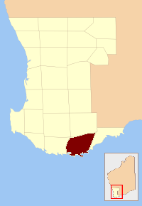
Plantagenet County, Western Australia facts for kids

Plantagenet County was an important area in the early days of Western Australia. It was one of 26 special land divisions created in 1829. These divisions helped people organize and manage the land as the colony grew.
Plantagenet County was located around the coastal town of Albany. Today, the area known as the Plantagenet Land District covers roughly the same space. This modern district is still used for keeping official records about land ownership.
What Was Plantagenet County?
Plantagenet County was like an old-fashioned way to divide up land. Imagine drawing lines on a map to create different sections. These sections were called counties. They were set up by the government in 1829.
The main purpose was to help manage the new colony. It made it easier to keep track of land. This included who owned which parts and how the land was being used.
Why Were Counties Created?
When settlers first arrived in Western Australia, there was a lot of new land. The government needed a system to organize it all. Creating counties helped with several things:
- Land Grants: It made it simpler to give out land to new settlers.
- Mapping: It helped cartographers (map makers) draw accurate maps of the colony.
- Administration: It provided clear boundaries for local government and services.
These counties were a key part of how Western Australia was first settled and developed. They helped bring order to the vast new territory.
How Do Old Counties Relate to Today?
The system of 26 counties isn't used for everyday government anymore. Instead, Western Australia uses different types of local government areas. However, the old county boundaries still have a purpose.
The Plantagenet Land District is a good example. This district uses boundaries very similar to the old Plantagenet County. It's mainly used for official land titles and property records. So, even though the name "county" isn't common for these areas now, their historical lines still help us understand land ownership today.
 | George Robert Carruthers |
 | Patricia Bath |
 | Jan Ernst Matzeliger |
 | Alexander Miles |

