Ponter's Ball Dyke facts for kids
Quick facts for kids Ponter's Ball Dyke |
|
|---|---|
 |
|
| Location | near Glastonbury, Somerset, England |
| Reference no. | Somerset 23564 |
| Lua error in Module:Location_map at line 420: attempt to index field 'wikibase' (a nil value). | |
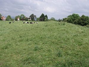
Ponter's Ball Dyke is an old, long earth wall and ditch near Glastonbury in Somerset, England. It crosses an ancient road that leads towards the area once known as the Isle of Avalon. This earthwork has a raised bank and a ditch next to it on the east side. It stretches across a ridge of land between Glastonbury and West Pennard. Both ends of the dyke disappear into what used to be swampy land.
Today, you can see about 1 kilometre of the dyke. The modern A361 road cuts through it. Three public footpaths also cross it. The way the ancient road goes through the dyke is not a straight line. This suggests that the gap was built that way on purpose.
Digging Up the Past
Archaeologists have dug at Ponter's Ball Dyke a few times. Arthur Bulleid first explored it in 1909. Later, in 1970, Peter Poyntz Wright and the Glastonbury Antiquarian Society did more digging.
Bulleid's digging showed that the earth bank was about 9 feet (2.7 meters) high. It was made of layers of yellow and grey clay. The ditch next to it was 12 feet (3.7 meters) deep. It was dug into hard blue marl, which is a type of soil.
During these digs, archaeologists did not find many important items. They only found small pieces of pottery. These pieces came from both prehistoric times and the Middle Ages.
What Was It For?
Experts are not completely sure why Ponter's Ball Dyke was built. One idea is that it was part of a much longer defensive wall. This wall might have been connected to another earthwork called New Ditch, about three miles (4.8 km) away. New Ditch is built in a similar style.
Some people think it was part of a large Celtic holy place from around 300 BC. Others believe it was built after the Roman period. They connect it to people living on Glastonbury Tor during the Dark Ages. However, the 1970 excavation suggested it might be from the 12th century or even later.
New technology, like LiDAR data, helps us understand the area better. It shows that the ditch likely ended in marshy land. This was before people dug channels to drain the water. This helps explain why the dyke doesn't stretch further.
There is also a claim that Ponter's Ball Dyke forms part of a giant picture on the ground. This picture is supposedly a Capricorn shape in the "Temple of the Stars." This "temple" is an alleged ancient site around Glastonbury.
Where Did the Name Come From?
The name "Ponter's Ball" is thought to come from Latin words. "Pontis vallum" means "the bridge over the ditch." In the early 1800s, it was called "Ponting's Ball." By 1876, it was sometimes called "Fronter's Ball." Another idea is that the name comes from "Portarius." This was the name of a family who owned land at Havyatt near Glastonbury.

