
Porcupine Gorge facts for kids
Quick facts for kids Porcupine Gorge |
|
|---|---|

Coal seams in Porcupine Gorge
|
|

Porcupine Gorge
Location in Queensland
|
|
| Depth | 40 |
| Geology | |
| Type | Gorge |
| Geography | |
| Rivers | Galah Creek |
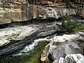
Porcupine Gorge is a huge natural gorge located in Porcupine, Australia. It's found in the Flinders Shire in North West Queensland. This amazing place is part of the Porcupine Gorge National Park, which helps protect its unique features. You can get to the gorge and the park by using the Kennedy Development Road.
The gorge is carved into sandstone rock, reaching up to 40 meters (about 130 feet) deep. During the dry winter months, the bottom of the gorge has many waterholes. But in the wet season, it turns into a powerful river that has dug out this deep canyon over time.
Every year, a fun event called the Porcupine Gorge Challenge takes place here. It starts at a spot called The Pyramid, right at the bottom of the gorge. The gorge is also a fantastic spot for seeing many different kinds of birds.
Exploring Porcupine Gorge's Rock Layers
The rocks at Porcupine Gorge tell an amazing story about Earth's past. Geologists study these layers to understand how the land changed over millions of years. Each layer, or "formation," gives us clues about ancient environments, like swamps, rivers, and coastlines.
Betts Creek Beds: Ancient Swamps and Coal
The oldest rock layers you can see are called the Betts Creek Beds. These layers are mostly made of fine mudstone and siltstone. They also contain special layers of coal. This coal formed from ancient plants that died in swamps.
Scientists have found fossils of Glossopteris leaves here. These plants lived during the Permian period, a very long time ago. Finding these fossils helps us know how old the rocks are. It also shows that this area was once a swampy place, perfect for making coal.
Higher up in these beds, you'll find sandstone layers. These sandstones show signs of old river channels. This means that after the swamps, rivers started flowing through the area.
How Faults Changed the Rocks
A crack in the Earth, called a normal fault, cuts through these sandstone layers. This fault allowed hot water, called hydrothermal fluids, to move through the rocks. This hot water changed the color of the sandstone. On one side of the fault, the sandstone is much whiter. This is because the hot water washed away iron from the rock. On the other side, the iron stayed, making the rock darker. This fault also created broken rock pieces, showing how powerful the water flow was.
Warang Sandstone: River Deposits and Iron Stains
Above the Betts Creek Beds is a rock unit called the Warang Sandstone. This sandstone formed from rivers flowing during the Early to Mid-Triassic period. It's made of sand that was carried by these ancient rivers.
Faults and Iron Stains in Sandstone
Where the Warang Sandstone meets the Betts Creek Beds, there are more cracks in the rock. These cracks, called strike-slip faults, also allowed hot water from below to rise. This hot water carried iron that had been washed out of the lower rocks. This iron then settled in the cracks and pores of the Warang Sandstone, creating dense, reddish-brown stains.
As you move up, you can see how these fluids created interesting patterns. The sandstone broke into blocky shapes, trapping the iron-rich water. This created what looks like folded patterns, but they are actually "boxwork concretions" – places where the iron hardened in a box-like shape.
River Channels and Weathering
Higher up, you can clearly see more river channels. These channels are filled with fine sand and some coarser material. Layers of mudstone and shale were squashed by the weight of the sand above them. You can also see imprints where softer mud pieces were carried by the rivers and then weathered away.
The top parts of the Warang Sandstone have large overhangs and honeycomb shapes. These are formed by modern-day flash floods and also by ancient river channels. The sandstone here changes color from red to yellow to white. This color change is due to water washing away minerals over time.
Blantyre Sandstone: Jurassic River Channels
The Blantyre Sandstone continues the story of river channels, but this time from the Jurassic period. It's not as easy to see up close, but we can still learn about it.
These layers also show signs of old river channels filled with coarse sand. You can see lines and shapes left by the water flow. There are also places where mud pieces were once present but have now weathered away, leaving large gouges in the rock face. Higher up, the sandstone shows "trough cross-stratification," which are curved layers that tell us about the direction the ancient rivers flowed.
The Blantyre Sandstone has many cracks, which suggests that hot water didn't affect it as much. It also seems that the environment here might have been drier at times, possibly with droughts.
Gilbert River Formation: Alluvial Fans and Volcanic Rocks
The youngest rock layer is the Gilbert River Formation. This layer is made of a mix of different sized rocks, including pebbles and cobbles. These rocks were carried by fast-moving water, likely from "alluvial fans." Alluvial fans are fan-shaped deposits of sediment that form when rivers flow out of mountains onto a flat plain.
This formation contains pieces of volcanic rock and chert. This tells us that there were volcanoes or volcanic rocks nearby when these layers were forming. The way the rocks are laid down shows that the water flow was very strong, able to move large amounts of sediment.
The very top of the Gilbert River Formation is "baked" by a layer of volcanic rock called the Sturgeon Basalt that flowed over it. This baking created a hard, changed rock layer.
Images for kids
-
Coal seams in Porcupine Gorge
]
