Port Neville facts for kids
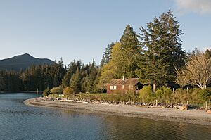
Port Neville is a beautiful bay and port located on the north side of Johnstone Strait in British Columbia, Canada. It's part of the stunning Central Coast region.
The small community of Port Neville used to have a post office until 2013. It is found on the east side of a narrow waterway that leads into Johnstone Strait. This waterway is actually an inlet, which is a long, narrow arm of the sea that stretches inland. The community is located at 50°30′00″N 126°05′00″W / 50.50000°N 126.08333°W.
Contents
Indigenous History and Reserves
Port Neville is home to important lands for the Kwakwakaʼwakw peoples, specifically the Tlowitsis Nation. These lands are called Indian Reserves.
Port Neville Indian Reserve No. 4
Port Neville Indian Reserve No. 4, also known as Port Neville 4, is located at the top end of the port, south of Fulmore Lake. This reserve is about 14.9 hectares (about 37 acres) in size. It is managed by the Tlowitsis Nation, one of the First Nations governments of the Kwakwaka'wakw people. Its coordinates are 50°34′00″N 125°56′00″W / 50.56667°N 125.93333°W.
Hanatsa Indian Reserve No. 6
Another reserve in the area is Hanatsa Indian Reserve No. 6, or Hanatsa 6. This reserve is much larger, at 95.1 hectares (about 235 acres). It is located on the south shore of the upper part of Port Neville. You can find it at 50°32′00″N 125°58′00″W / 50.53333°N 125.96667°W. It is east of Hanatsa Point, which is at 50°31′47″N 125°59′54″W / 50.52972°N 125.99833°W. This point marks a narrow section between the upper part of the port and its wider opening.
Ancient Fort: xudzedzalis
On the east shore of Port Neville, there is an ancient fort called xudzedzalis. This fort was used by the Matilpi group of the Kwakwaka'wakw people. Its name means "fort on flat on beach." The fort's location is 50°31′20″N 126°03′40″W / 50.52222°N 126.06111°W.
Naming of Port Neville
This "very snug and commodious port" was named by Captain George Vancouver. He likely named it in honor of Lieutenant John Neville of the Royal Marines. However, there is some uncertainty about exactly which John Neville he was referring to.
 | Aaron Henry |
 | T. R. M. Howard |
 | Jesse Jackson |


