Porto Novo, Cape Verde (municipality) facts for kids
Quick facts for kids
Porto Novo
|
|
|---|---|
|
Municipality
|
|
 |
|
| Country | Cape Verde |
| Island | Santo Antão |
| Area | |
| • Total | 564.3 km2 (217.9 sq mi) |
| Population
(2010)
|
|
| • Total | 18,028 |
| • Density | 31.948/km2 (82.744/sq mi) |
| ID | 13 |
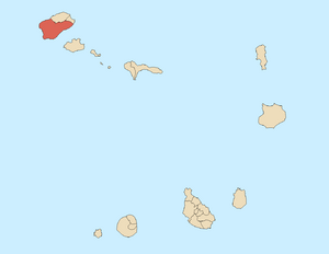
Porto Novo is a special area, like a county or district, in Cape Verde. It is located on the southern part of Santo Antão Island. This area covers most of the island, about 72% of it! It is also home to almost half of the island's people. In 2010, about 18,028 people lived there.
The main town and capital of this area is also called Porto Novo. The highest point in the municipality, and on the whole island, is Tope de Coroa. This peak is about 1,979 meters (6,493 feet) tall. The municipality of Porto Novo was created in 1962. Before that, its parts were part of an older municipality called Paul.
Parts of Porto Novo
The municipality of Porto Novo is divided into two smaller areas called freguesias (civil parishes). Think of these as smaller towns or districts within the main municipality.
- Santo André
- São João Baptista
How Many People Live Here?
The chart below shows how the number of people living in Porto Novo has changed over many years. You can see how the population grew and sometimes changed between 1940 and 2010.
| Year | Population |
|---|---|
| 1940 |
10,366
|
| 1950 |
7,565
|
| 1960 |
10,683
|
| 1970 |
13,750
|
| 1980 |
13,236
|
| 1990 |
14,873
|
| 2000 |
17,191
|
| 2010 |
18,028
|
Friendship Cities
Porto Novo has special friendships with three cities in Portugal. These are called "twin towns" or "sister cities." It means they work together and share culture.
- Angra do Heroísmo
- Estarreja
- Tavira
See also
 In Spanish: Porto Novo (Cabo Verde) para niños
 | Toni Morrison |
 | Barack Obama |
 | Martin Luther King Jr. |
 | Ralph Bunche |

