
Prettyboy Reservoir facts for kids
Quick facts for kids Prettyboy Reservoir |
|
|---|---|
 |
|

Prettyboy Reservoir
Location in Maryland

Prettyboy Reservoir
Location in the United States
|
|
| Location | Baltimore County, Maryland |
| Coordinates | 39°38′36″N 76°44′27″W / 39.6432°N 76.7408°W |
| Type | reservoir |
| Primary inflows | Gunpowder Falls |
| Primary outflows | Lochraven |
| Basin countries | United States |
| Surface area | 206.5 km2 (79.7 sq mi) |
| Average depth | 29 ft (8.8 m) |
| Max. depth | 128.6 ft (39.2 m) |
| Water volume | 19 billion US gallons (72 hm3) |
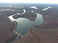
Prettyboy Reservoir is a large lake in northern Baltimore County, Maryland. It covers about 206.5 square kilometers. Even though it is in Baltimore County, the City of Baltimore owns the reservoir and the forests around it. This is because the reservoir helps supply drinking water to the city.
Prettyboy Reservoir is one of three important reservoirs that provide water to Baltimore City, Baltimore County, and northern Anne Arundel County, Maryland. Together with Loch Raven Reservoir, it supplies about 61% of the drinking water for the Baltimore area. This makes Prettyboy Reservoir a "source water" area, meaning its water is used for drinking. On average, the reservoir holds about 19 billion gallons of water.

Contents
How Prettyboy Reservoir Works
The water from Prettyboy Reservoir flows into Loch Raven Reservoir through the Gunpowder Falls. From Loch Raven, the water travels through a tunnel to treatment plants in Baltimore. There, it is cleaned and made safe to drink before being sent to homes and businesses.
Building the Dam
The Prettyboy Dam was finished in 1932. It was built to hold back the Gunpowder Falls and create the reservoir. The dam's top is about 520 feet (158 meters) above sea level. The reservoir itself covers about 1,500 acres (6.1 square kilometers).

Fun Activities at Prettyboy Reservoir
Prettyboy Reservoir is a popular spot for many outdoor activities. The area around the reservoir is part of the Gunpowder Falls State Park. This park offers great opportunities for people to enjoy nature.
Exploring the Outdoors
You can go hiking on the trails around the reservoir. Many people also enjoy mountain biking and road cycling on the roads nearby. Fishing and boating are allowed on the reservoir, but swimming is not. If you like hunting, you can do archery here with a special permit.
Water Adventures
For those who love water sports, the Lower Gunpowder Falls river is a great place for kayaking and tubing. This part of the river starts from the dam and goes down to Falls Road or Masemore Road. The river usually has calm sections and some small rapids. When there are heavy rains, the dam might open its gates to let out extra water. This makes the river's water level higher, which is exciting for kayakers.
Safety and History
The areas around the metropolitan reservoirs, including Prettyboy, are patrolled by special officers. These officers are from the Department of Public Works and sometimes the Baltimore City Police. They help keep everyone safe and protect the water supply.
A Special Rescue
On June 23, 2008, Prettyboy Reservoir was the site of an important rescue. The Baltimore County Fire Department used a helicopter to rescue a woman who was hurt while walking her dog. This was the first time the department used this type of helicopter rescue, which they had just learned two weeks before.
How Prettyboy Got Its Name
There's a story about how Prettyboy Reservoir got its name. It's said that the lake was named after a settler's horse, named Pretty Boy. The horse supposedly drowned in a creek that was once in the area.
Images for kids
-
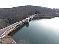
Water flowing from Prettyboy Dam.
-
Another view of Prettyboy Dam.


