
Prince Edward Islands facts for kids

Map of Prince Edward Islands
|
|

Orthographic projection centred on the Prince Edward Islands
|
|
| Geography | |
|---|---|
| Location | Indian Ocean |
| Coordinates | 46°53′19″S 37°44′08″E / 46.888739°S 37.735658°E |
| Area | 335 km2 (129 sq mi) |
| Highest elevation | 1,242 m (4,075 ft) |
| Highest point | Mascarin Peak |
| Administration | |
| Demographics | |
| Population | 0 (Uninhabited – Permanent) 50 (Research Staff – Non-Permanent) |
|
Designations
|
|
| Designated: | 24 January 1997 |
|---|---|
| Reference #: | 1688 |
The Prince Edward Islands are two small islands located far away in the Indian Ocean. They are part of South Africa. These islands are special because they are in a very cold area called the sub-antarctic region.
The two main islands are called Marion Island and Prince Edward Island. Marion Island is named after a French explorer, Marc-Joseph Marion du Fresne. Prince Edward Island is named after Prince Edward, a British prince.
Protecting the Prince Edward Islands
These islands are very important for nature. They have been made into "Special Nature Reserves" by South Africa. This means that most activities on the islands are not allowed. Only scientific research and work to protect the environment can happen there.
In 2013, the waters around the islands also became a "marine protected area". This helps protect the ocean animals and plants living near the islands.
Life on the Islands
No people live on the Prince Edward Islands permanently. However, a small group of scientists and staff stay on Marion Island. They work at a research station run by the South African National Antarctic Programme. These researchers study the weather (meteorology) and the animals and plants (biology) of the islands.
Images for kids
-
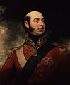
Prince Edward, after whom the islands are named
-
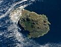
Prince Edward Island as seen from outer space on 5 May 2009.
-

Marion Island as seen from outer space on 5 May 2009
-
Logo of Marion Island
-
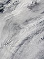
Cloud patterns over the Prince Edward Islands


See also
 In Spanish: Islas del Príncipe Eduardo para niños
