Puerto Salgar facts for kids
Quick facts for kids
Puerto Salgar
|
|||
|---|---|---|---|
|
Municipality and town
|
|||

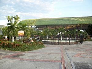
Sportscenter of Puerto Salgar
|
|||
|
|||

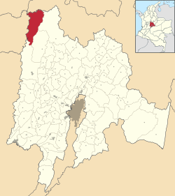
Location of the municipality and town inside Cundinamarca Department of Colombia
|
|||
| Country | |||
| Department | |||
| Area | |||
| • Municipality and town | 515.9 km2 (199.2 sq mi) | ||
| • Urban | 1.98 km2 (0.76 sq mi) | ||
| Population
(Census 2018)
|
|||
| • Municipality and town | 15,019 | ||
| • Density | 29.112/km2 (75.400/sq mi) | ||
| • Urban | 11,082 | ||
| • Urban density | 5,597/km2 (14,500/sq mi) | ||
| Time zone | UTC-5 (Colombia Standard Time) | ||
Puerto Salgar is a town and a municipality in Colombia. It is located in the northwest part of the Cundinamarca department. A municipality is like a local government area. A department is a larger region, similar to a state or province.
Puerto Salgar became known around the world because of the Palanquero Air Base. This air base is a military airport. In 2009, there were talks about the base possibly hosting US military personnel. This would have made it a replacement for another base called Manta Air Base.
On December 29, 2015, Puerto Salgar had the highest temperature ever recorded in Colombia. It reached 45.0 °C (113.0 °F). That's really hot!
Climate in Puerto Salgar
Puerto Salgar has a warm climate. The weather here is measured at the Palanquero Air Base. The average temperature throughout the year is about 28.7 degrees Celsius.
The hottest months are usually July and August. The coolest months are October and November.
It rains a lot in Puerto Salgar. The wettest months are April, May, and October. The driest months are July and August. There are about 155 rainy days each year.
The air is quite humid, especially from October to December. The sun shines for many hours each day, even with the rain.
| Climate data for Puerto Salgar (Captain Germán Olano Moreno Air Base), elevation 172 m (564 ft), (1981–2010) | |||||||||||||
|---|---|---|---|---|---|---|---|---|---|---|---|---|---|
| Month | Jan | Feb | Mar | Apr | May | Jun | Jul | Aug | Sep | Oct | Nov | Dec | Year |
| Mean daily maximum °C (°F) | 33.1 (91.6) |
33.6 (92.5) |
33.4 (92.1) |
33.0 (91.4) |
33.2 (91.8) |
33.7 (92.7) |
34.9 (94.8) |
35.2 (95.4) |
34.2 (93.6) |
32.5 (90.5) |
32.2 (90.0) |
32.5 (90.5) |
33.4 (92.1) |
| Daily mean °C (°F) | 28.6 (83.5) |
28.9 (84.0) |
28.7 (83.7) |
28.5 (83.3) |
28.7 (83.7) |
28.9 (84.0) |
29.4 (84.9) |
29.7 (85.5) |
28.8 (83.8) |
28.0 (82.4) |
28.0 (82.4) |
28.3 (82.9) |
28.7 (83.7) |
| Mean daily minimum °C (°F) | 22.6 (72.7) |
22.2 (72.0) |
22.4 (72.3) |
22.6 (72.7) |
22.6 (72.7) |
22.5 (72.5) |
22.5 (72.5) |
22.6 (72.7) |
22.5 (72.5) |
22.1 (71.8) |
22.3 (72.1) |
22.5 (72.5) |
22.4 (72.3) |
| Average precipitation mm (inches) | 86.2 (3.39) |
92.1 (3.63) |
143.6 (5.65) |
232.7 (9.16) |
232.8 (9.17) |
106.3 (4.19) |
82.9 (3.26) |
98.5 (3.88) |
182.5 (7.19) |
296.0 (11.65) |
247.5 (9.74) |
147.8 (5.82) |
1,948.7 (76.72) |
| Average precipitation days | 9 | 8 | 13 | 17 | 17 | 13 | 11 | 11 | 16 | 19 | 18 | 12 | 155 |
| Average relative humidity (%) | 73 | 71 | 73 | 75 | 74 | 72 | 66 | 66 | 71 | 76 | 77 | 76 | 73 |
| Mean monthly sunshine hours | 139.5 | 112.9 | 117.8 | 138.0 | 161.2 | 156.0 | 189.1 | 186.0 | 162.0 | 155.0 | 150.0 | 139.5 | 1,807 |
| Mean daily sunshine hours | 4.5 | 4.0 | 3.8 | 4.6 | 5.2 | 5.2 | 6.1 | 6.0 | 5.4 | 5.0 | 5.0 | 4.5 | 4.9 |
| Source: Instituto de Hidrologia Meteorologia y Estudios Ambientales | |||||||||||||
See also
 In Spanish: Puerto Salgar para niños
 | George Robert Carruthers |
 | Patricia Bath |
 | Jan Ernst Matzeliger |
 | Alexander Miles |


