Puerto Tejada, Cauca facts for kids
Quick facts for kids
Puerto Tejada, Cauca
|
|||
|---|---|---|---|
|
Municipality and town
|
|||
|
|||

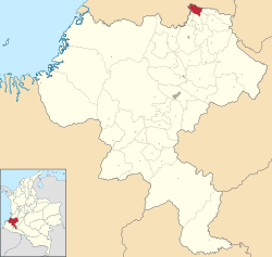
Location of the municipality and town of Puerto Tejada, Cauca in the Cauca Department of Colombia.
|
|||
| Country | |||
| Department | Cauca Department | ||
| Area | |||
| • Municipality and town | 101.1 km2 (39.0 sq mi) | ||
| • Urban | 4.3 km2 (1.7 sq mi) | ||
| Population
(2020 est.)
|
|||
| • Municipality and town | 46,215 | ||
| • Density | 457.12/km2 (1,183.9/sq mi) | ||
| • Urban | 35,821 | ||
| • Urban density | 8,330/km2 (21,580/sq mi) | ||
| Time zone | UTC-5 (Colombia Standard Time) | ||
| Climate | Am | ||
Puerto Tejada is a town and a municipality in the Cauca Department of Colombia. It is known for its rich history and warm, tropical weather. The town is home to about 46,000 people.
Contents
History of Puerto Tejada
Puerto Tejada officially became a town on September 17, 1897. It was named after General Manuel Tejada Sanchez. The town was founded in an area called Monte Oscuro, which means "Dark Mountain."
Early Settlements and Freedom
For a long time, even before it was a town, this area was a safe place for people who had escaped slavery. These communities, called maroons, settled in Monte Oscuro. The thick forests there helped them stay hidden.
After slavery ended in Colombia in 1852, these communities grew. People who were once enslaved, and the families of the maroons, started organized farms. They grew crops like coffee, corn, plantains, cassava, and cacao. New settlers from other parts of Colombia also joined them. This led to a strong farming economy in the late 1800s and early 1900s.
Founding and Growth
The first people to live here settled near the Palo and Paila rivers. As Puerto Tejada grew into a town, other small towns also started to appear nearby.
Climate
Puerto Tejada has a tropical monsoon climate, which means it is generally hot and humid all year round. It experiences a lot of rain, especially during certain months.
| Climate data for Puerto Tejada (Ing Bengala), elevation 1,000 m (3,300 ft), (1981–2010) | |||||||||||||
|---|---|---|---|---|---|---|---|---|---|---|---|---|---|
| Month | Jan | Feb | Mar | Apr | May | Jun | Jul | Aug | Sep | Oct | Nov | Dec | Year |
| Mean daily maximum °C (°F) | 30.0 (86.0) |
30.3 (86.5) |
30.2 (86.4) |
29.6 (85.3) |
29.6 (85.3) |
29.7 (85.5) |
30.2 (86.4) |
30.6 (87.1) |
30.3 (86.5) |
29.5 (85.1) |
29.2 (84.6) |
29.5 (85.1) |
29.9 (85.8) |
| Daily mean °C (°F) | 24.1 (75.4) |
24.2 (75.6) |
24.1 (75.4) |
23.9 (75.0) |
24.0 (75.2) |
24.0 (75.2) |
24.2 (75.6) |
24.3 (75.7) |
24.1 (75.4) |
23.9 (75.0) |
23.8 (74.8) |
23.9 (75.0) |
24.0 (75.2) |
| Mean daily minimum °C (°F) | 18.0 (64.4) |
18.0 (64.4) |
18.1 (64.6) |
18.1 (64.6) |
18.3 (64.9) |
17.9 (64.2) |
17.5 (63.5) |
17.5 (63.5) |
17.7 (63.9) |
17.9 (64.2) |
18.0 (64.4) |
18.1 (64.6) |
17.9 (64.2) |
| Average precipitation mm (inches) | 96.8 (3.81) |
94.6 (3.72) |
144.7 (5.70) |
203.6 (8.02) |
147.7 (5.81) |
87.3 (3.44) |
47.0 (1.85) |
43.0 (1.69) |
97.4 (3.83) |
147.5 (5.81) |
166.7 (6.56) |
113.5 (4.47) |
1,389.7 (54.71) |
| Average precipitation days | 10 | 9 | 14 | 16 | 16 | 10 | 8 | 8 | 12 | 16 | 16 | 12 | 144 |
| Average relative humidity (%) | 80 | 80 | 80 | 81 | 81 | 81 | 79 | 78 | 78 | 80 | 81 | 81 | 80 |
| Source: Instituto de Hidrologia Meteorologia y Estudios Ambientales | |||||||||||||
See also
 In Spanish: Puerto Tejada para niños
 | Bessie Coleman |
 | Spann Watson |
 | Jill E. Brown |
 | Sherman W. White |


