Río Bravo, Suchitepéquez facts for kids
Quick facts for kids
Rio Bravo
|
|
|---|---|
|
Municipality
|
|
| Country | Guatemala |
| Department | Suchitepéquez Department |
| Municipality | Río Bravo |
| Area | |
| • Total | 175 km2 (68 sq mi) |
| Elevation | 46 m (151 ft) |
| Population
(2018 census)
|
|
| • Total | 27,606 |
| • Density | 157.7/km2 (408.6/sq mi) |
| Time zone | CST |
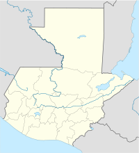
Río Bravo is a town and a municipality located in the Suchitepéquez department of Guatemala. In 2018, the town had a population of 15,391 people. The municipality of Río Bravo was officially created on December 10, 1951.
This area was once known as San Francisco Río Bravo. It used to be part of the Santa Barbara municipality. The town got its name because it was built close to the Grande de Zacapa River. Río Bravo is about 127 kilometers (79 miles) away from Guatemala City, the capital of Guatemala. It is located near the Pacific Ocean coast. Because of this, the weather is usually warm, around 32°C (90°F). Sometimes it can drop to 22°C (72°F) or rise to 37°C (99°F).
Contents
What is the Economy Like in Río Bravo?
The main ways people make a living in Río Bravo are through farming, raising animals, and agribusiness (which means businesses related to farming). The most important crops grown here are sugar cane, rubber, corn, beans, bananas, and plantains. The municipality covers an area of 175 square kilometers (67.6 square miles).
History of Río Bravo
The town of Río Bravo started as a small settlement called San Francisco Caserío. It was located near the Río Grande. For a while, it was known as San Francisco Río Bravo. At that time, it was just a village that belonged to the municipality of Santa Barbara.
On December 10, 1951, something important happened. The Congress of Guatemala passed Decree No. 226. This law made Río Bravo its own separate municipality. Its land was taken from the Santa Barbara municipality. This big event was celebrated in the public square of San Francisco Río Bravo.
The first mayor of the new municipality was Mr. José Fuentes. He was chosen by a special committee that worked for independence. Later, the first mayor to be elected by the people was Mr. Daniel Foronda. A group called the Civic Committee of Río Bravo worked hard to make the municipality happen. They had the support of 23 property owners and most of the local residents. A census taken on April 3, 1950, showed that Río Bravo had 1,300 people living there before it became a municipality.
Who Lives in Río Bravo?
Most of the people living in Río Bravo are Latino. There are also Mayan communities. These Mayan groups live in places like Agrarian Community Sololateca and Colonia La Campesina.
Water Sources in Río Bravo
The municipality of Río Bravo has many water sources. There are 14 rivers, 1 stream, and 22 trenches that flow through the area. The most important rivers are the San Francisco River, the Río Grande River, and the Siguacán River.
In the higher parts of the municipality, there are some smaller water sources. The main town gets its water by taking it from a river. Other water sources include wells and springs. For example, there's a well in La Colonia and another source in Lotificación Santo Tomas, Colonia Las Flores. There are also hot springs on a farm called El Recuerdo. You can find a small lake on the Mangales farm and in Lotificación Río Seco.
See Also
 | Sharif Bey |
 | Hale Woodruff |
 | Richmond Barthé |
 | Purvis Young |


