
Red Rock Landing Conservation Area, Perry County, Missouri facts for kids
Quick facts for kids Red Rock Landing Conservation Area |
|
|---|---|

Red Rock Landing Conservation Area
|
|
| Location | Missouri, United States |
| Established | 1994 |
The Red Rock Landing Conservation Area is a special natural place in eastern Perry County, Missouri. It's located about ten miles east of Perryville, Missouri, right at the end of County Road 350. The Missouri Conservation Department created this area in November 1994. They bought 554 acres of land along the famous Mississippi River to protect it and allow people to enjoy nature.
Contents
Exploring Red Rock Landing
Red Rock Landing Conservation Area covers 554 acres of land. It stretches for about one mile along the mighty Mississippi River. It also has about half a mile of frontage along Cinque Hommes Creek. This area is a great spot for outdoor adventures.
What You'll Find There
This conservation area has a mix of different landscapes. You can find seven small ponds, which together cover about five acres. Most of the area, about 419 acres, is covered in beautiful timber (forest). There are also 60 acres of open fields near the river and 70 acres of fields on higher ground.
Why This Area Was Created
The Missouri Conservation Department bought this land in 1994 for a main reason: to give the public a place to go fishing. This spot has some of the best natural river habitats left along this part of the Mississippi River. The riverbanks here have good water depth and places for fish to hide. This makes it an excellent place for bank fishing, especially for catfish and other large river fish.
Forests and Wildlife
The forests in the Red Rock Landing area are carefully managed. This helps the trees grow better and improves the overall health of the forest. It also helps different kinds of trees and plants to thrive. This management helps create a good home for various wildlife species.
Activities for Visitors
If you love the outdoors, Red Rock Landing has something for you!
- Camping: There's a camping area with three special campsites. Each site has a fire ring for campfires, a picnic table for meals, a BBQ grill, and a gravel pad for your tent or RV.
- Hiking: You can explore the area on its hiking trails. These trails let you see the different parts of the conservation area, from the forests to the riverbanks.
- Fishing: As mentioned, it's a prime spot for fishing along the Mississippi River.
Important River Information
The water levels of the Mississippi River can change a lot. Because of this, sometimes the conservation area cannot be reached by road. If the Mississippi River level goes over 20 feet on the Chester Power gauge, the road leading to the area becomes flooded. It's always a good idea to check river levels before you plan your visit.
Images for kids
-
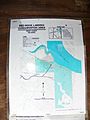
Site map
-
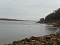
View of the Mississippi River
-
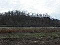
Field and bluffs


