Ringgold, Ohio facts for kids
Quick facts for kids
Ringgold, Ohio
|
|
|---|---|

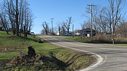
State Route 78 in the community's east side
|
|
| Country | United States |
| State | Ohio |
| County | Morgan |
| Elevation | 932 ft (284 m) |
| Time zone | UTC-5 (Eastern (EST)) |
| • Summer (DST) | UTC-4 (EDT) |
| Area code(s) | 740 |
| GNIS feature ID | 1076743 |
Ringgold is a small place in Morgan County, Ohio, in the United States. It is called an unincorporated community. This means it's a group of homes and businesses that isn't officially a town or city with its own local government. Ringgold is found where two main roads meet: State Route 78 and State Route 555. It is about 7.5 miles (12.1 km) southwest of a town called Malta.
History of Ringgold
Ringgold was officially planned out and marked on a map in 1846. This process is called platting. The community was named after Samuel Ringgold, who was an officer in the United States Army.
Early Services in Ringgold
A post office was opened in Ringgold in 1847. This was an important place where people could send and receive letters and packages. The post office served the community for many years before it closed down in 1939.
 | Tommie Smith |
 | Simone Manuel |
 | Shani Davis |
 | Simone Biles |
 | Alice Coachman |


