River Asker facts for kids
Quick facts for kids Asker |
|
|---|---|

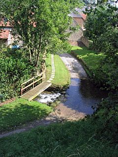
A ford on the River Asker near Uploders
|
|
|
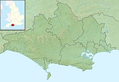
Location within Dorset
|
|
| Country | United Kingdom |
| County | Dorset |
| Physical characteristics | |
| Main source | Eggardon Hill, near Askerswell, Dorset 50°45′N 2°39′W / 50.750°N 2.650°W |
| River mouth | Bridport, Dorset 50°43′N 2°45′W / 50.717°N 2.750°W |
| Length | 13.378 km (8.313 mi) |
| Basin features | |
| Basin size | 25.484 km2 (9.839 sq mi) |
| Tributaries |
|
The River Asker is a small river located in Dorset, England. It starts high up on the chalky slopes of Eggardon Hill. This is about 5 miles (8 km) east of the town of Bridport. The river flows for about 8 miles (13 km) through the beautiful Dorset countryside.
The Asker's Journey
The River Asker begins its journey flowing west-northwest. It passes through several charming villages. One of these is Askerswell, which actually gets its name from the river itself!
Next, the river reaches Uploders. Here, many houses have gardens that back right onto the river. It then continues to Loders. After Loders, the river turns west towards Bradpole.
At Bradpole, a smaller stream called Mangerton Brook joins the River Asker from the north. The Asker then flows southwest into the town of Bridport. It goes under busy roads like the A3066 and B3162.
In Bridport, you can see weirs in the river. These are small dams that control the water flow. There are also fish ladders, which help fish swim upstream past the weirs.
South of the B3162 road, between Bridport and Bothenhampton, the river forms a border. It marks the western edge of the Askers Meadow Nature Reserve. This special area was made a Local Nature Reserve in 2004. Finally, the River Asker flows under the B3157 road. It then joins the River Brit right next to Palmers Brewery in the southern part of Bridport.
How Healthy is the River Asker?
The Environment Agency checks the water quality of rivers in England. They give each river system an overall "ecological status." This status can be one of five levels: high, good, moderate, poor, or bad.
To figure out this status, they look at different things.
- Biological status checks the types and numbers of living things in the water. This includes tiny invertebrates (like insects without backbones), flowering plants, and fish.
- Chemical status looks at how much of different chemicals are in the water. They compare these amounts to safe levels. Chemical status is either "good" or "fail."
Here is how the River Asker's water quality was rated in 2016:
| Section | Ecological Status |
Chemical Status |
Overall Status |
Length | Catchment | Channel |
|---|---|---|---|---|---|---|
| Asker | Poor | Good | Poor | 11.796 km (7.330 mi) | 23.699 km2 (9.150 sq mi) | |
| Mangerton Brook | Good | Good | Good | 13.378 km (8.313 mi) | 25.484 km2 (9.839 sq mi) |
As you can see, in 2016, the main part of the River Asker had a "poor" ecological status. This means there might have been issues with the plants, insects, or fish living there. However, its chemical status was "good." The Mangerton Brook, which joins the Asker, had "good" ratings for both ecological and chemical status.
 | Jessica Watkins |
 | Robert Henry Lawrence Jr. |
 | Mae Jemison |
 | Sian Proctor |
 | Guion Bluford |


