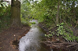
River Ter SSSI facts for kids
The River Ter SSSI is a special part of the River Ter and its banks near Great Leighs in Essex, England. It's called a Site of Special Scientific Interest (SSSI) because it's a really important place for understanding geology – that's the study of rocks and how the Earth is made. It's also part of something called the Geological Conservation Review, which helps protect important geological sites across the country.
| Site of Special Scientific Interest | |
 |
|
| Area of Search | Essex |
|---|---|
| Interest | Geological |
| Area | 6.4 hectares |
| Notification | 1994 |
| Location map | Magic Map |
Contents
What Makes the River Ter SSSI Unique?
The River Ter SSSI is a fantastic example of a lowland stream. These are rivers that flow through flat areas, often with gentle slopes. This particular stretch of the River Ter is important because it shows how such rivers behave naturally.
How the River Flows
The River Ter here is known as a "flashy" river. This means its water levels can change very quickly. After heavy rain, the river can rise fast, creating high flood peaks. However, during dry periods, the amount of water flowing (called "base flow") can be very low. This big difference between high and low water levels happens daily, monthly, and even yearly.
The river flows over "glacial till," which is a type of soil left behind by ancient glaciers. This kind of ground doesn't absorb water very quickly, which also contributes to the river's fast changes in water level.
River Features and Changes
This SSSI shows many typical features of a lowland stream:
- Pool-riffle sequences: These are alternating deep, slow-moving sections (pools) and shallow, fast-moving sections (riffles). They are important for river health and different types of river life.
- Bank erosion: The river naturally wears away its banks, especially during floods. This process helps shape the river channel over time.
- Bedload transport: This refers to how the river moves rocks, sand, and gravel along its bottom. You can often see these materials being pushed or rolled by the water.
- Adjustments to flooding: The river's shape and size change in response to floods. Flooding can widen the river, move sediment, and create new features. Studying these changes helps scientists understand how rivers adapt.
Visiting the River Ter SSSI
Most of the River Ter SSSI is surrounded by thick plants and trees, making it hard to reach directly. However, there is a public footpath that runs along part of the north bank. This path is located east of a road called Cole Hill and is within the SSSI area. This means you can still experience a part of this special geological site.
 | Emma Amos |
 | Edward Mitchell Bannister |
 | Larry D. Alexander |
 | Ernie Barnes |

