
Rivière aux Chiens (Côte-de-Beaupré) facts for kids
Quick facts for kids Rivière aux Chiens |
|
|---|---|

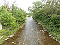
View from the bridge of route 360, upward (toward north-west)
|
|
| Country | Canada |
| Province | Quebec |
| Region | Capitale-Nationale |
| Regional County Municipality | La Côte-de-Beaupré Regional County Municipality |
| Municipality | Beaupré and Château-Richer |
| Physical characteristics | |
| Main source | Confluence of two mountain streams Beaupré 643 m 47°07′12″N 70°58′49″W / 47.12007°N 70.98038°W |
| River mouth | St. Lawrence River Beaupré 4 m 47°00′26″N 70°57′37″W / 47.00722°N 70.96027°W |
| Length | 170 km (110 mi) |
| Basin features | |
| Tributaries |
|
The Rivière aux Chiens (which means "River of the Dogs" in English) is a river in Quebec, Canada. It flows south into the Saint Lawrence River near the towns of Beaupré and Château-Richer.
This river is about 17 kilometers (10.5 miles) long. It starts high in the mountains and flows down to the big Saint Lawrence River. The lower part of the river valley is easy to reach by roads like Route 360 and Route 138. The middle part is more mountainous and harder to get to. The upper part is mostly forest and can be reached by a forest road.
The main activities in this area are forestry (cutting down trees) and agriculture (farming) in the flatter parts. The river usually freezes from early December to late March. It's safest to walk on the ice from mid-December to mid-March. The water level changes with the seasons and how much rain falls. The river usually floods in March or April when the snow melts.
River's Journey: Where it Starts and Ends
The Rivière aux Chiens begins where two mountain streams meet. This is in the mountains behind the Côte-de-Beaupré, north of Mont-Sainte-Anne. This starting point is about 3 kilometers (1.8 miles) northeast of another river called the Rivière des Sept Crans. It's also about 12.6 kilometers (7.8 miles) northwest of where the Rivière aux Chiens flows into the Saint Lawrence River.
From its source, the river drops about 639 meters (2,096 feet) as it flows for 17 kilometers (10.5 miles). Here's how its journey goes:
- It flows south for about 2.5 kilometers (1.5 miles). Along this part, it collects water from several smaller streams. It also goes through some rapids.
- Next, it flows southeast for about 1.8 kilometers (1.1 miles), passing through a long series of rapids.
- Then, it travels about 4.4 kilometers (2.7 miles) southeast, then south. This part is in a deep valley with many rapids, until it meets the Rivière des Sept Crans.
- It continues southeast for about 2.7 kilometers (1.7 miles) in a deep valley, still in a rapid area.
- For the next 2.2 kilometers (1.4 miles), it flows southeast, making a turn to the west. It passes through an area called the "Fourth Basin."
- Finally, it flows south for about 2.8 kilometers (1.7 miles), making a loop to the east and then a turn to the southwest. It then turns east until it reaches Route 360.
- The last 0.6 kilometers (0.4 miles) of the river flows east, passing under Route 138, until it reaches its mouth.
The last 1.0 kilometer (0.6 miles) of the river forms the border between the towns of Beaupré and Château-Richer.
The Rivière aux Chiens empties into the Saint Lawrence River on its northwest shore in Beaupré. This spot is across from the northern tip of Île d'Orléans, which is about 2.0 kilometers (1.2 miles) away. The river's mouth is located between Sainte-Anne-de-Beaupré (3.8 km northeast) and the village of Château-Richer (6.2 km southwest).
What's in a Name? The Story of "River of the Dogs"
The name "Rivière aux Chiens" (River of the Dogs) was first seen on maps around 1641. This suggests the name was used long before that.
In the past, when rivers flowed into the Estuary of Saint Lawrence, the word "dog" in a river's name often meant that seals were present. Seals were sometimes called "sea dogs." It might have even been a place where seals had their babies. When the French first settled in America, they hunted seals near Quebec City.
Historians are not completely sure why this river was named "River of the Dogs." Was it because of seals, or actual dogs? One idea comes from a historian named C.-E. Marquis. He suggested that the name might refer to stray dogs that the first settlers had to leave behind. This happened when the Kirke brothers attacked and occupied Quebec from 1629 to 1632, destroying a farm called Cape Tourmente.
A post office opened in this area in the late 1800s. It was called "Rivière-aux-Chiens" until 1964, when its name was changed to Sainte-Anne-de-Beaupré - West.
The name "Rivière aux Chiens" was officially recognized on April 4, 1982, by the Quebec Place Names Bank.
Images for kids
-
View of the bridge from Route 360, looking downstream (southeast)

