Rivière des Pins (Nicolet River tributary) facts for kids
Quick facts for kids Rivière des Pins |
|
|---|---|

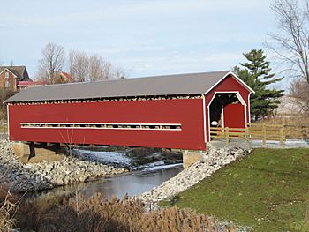
Rivière des Pins near Joseph-Édouard Perrault Bridge
|
|
| Country | Canada |
| Province | Quebec |
| Region | Centre-du-Québec |
| Regional County Municipality | Arthabaska |
| Physical characteristics | |
| Main source | Mountain streams Saint-Rémi-de-Tingwick 296 m (971 ft) 45°54′37″N 71°50′02″W / 45.91033°N 71.833896°W |
| River mouth | Nicolet River Saint-Albert-de-Warwick 108 m (354 ft) 46°00′29″N 72°02′36″W / 46.00806°N 72.04333°W |
| Length | 37.9 km (23.5 mi) |
| Basin features | |
| Tributaries |
|
The Rivière des Pins (which means River of the Pines in English) is a river in Quebec, Canada. It's a smaller river that flows into the Nicolet River. The Nicolet River then flows into the big Saint Lawrence River.
The Rivière des Pins flows through several towns. These include Saint-Rémi-de-Tingwick, Tingwick, Warwick, and Saint-Albert-de-Warwick. It is located in a region called Centre-du-Québec.
Where the River Flows
The Rivière des Pins starts from many small streams. These streams are found in farms and forests. They are located in the town of Saint-Rémi-de-Tingwick.
The River's Journey
From where it begins, the Rivière des Pins flows for about 37.9 km (23.5 mi). That's about 23.5 miles!
- It first flows towards the south-east, then turns west.
- It then heads north-west, passing through Tingwick.
- The river continues north-west, crossing Chemin Craig and Gleasson Road.
- It then reaches the town of Warwick.
- The river flows around the south side of the village of Warwick.
- Finally, it turns north-west again.
The Rivière des Pins ends by flowing into the Nicolet River. This meeting point is near the town of Saint-Albert-de-Warwick.
River's Name
The name "Rivière des Pins" was officially recognized on December 5, 1968. This was done by the Commission de toponymie du Québec. This group is in charge of naming places in Quebec.
 | Aurelia Browder |
 | Nannie Helen Burroughs |
 | Michelle Alexander |

