Rivière du Gouffre facts for kids
Quick facts for kids Rivière du Gouffre |
|
|---|---|

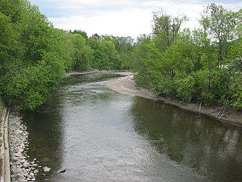
The Rivière du Gouffre at Baie-Saint-Paul.
|
|
| Country | Canada |
| Province | Quebec |
| Region | Capitale-Nationale |
| Regional County Municipality | Charlevoix Regional County Municipality |
| City | Baie-Saint-Paul |
| Physical characteristics | |
| Main source | Lac du Cœur Lac-Pikauba 823 m (2,700 ft) 47°50′55″N 70°34′04″W / 47.848478°N 70.567861°W |
| River mouth | St. Lawrence River La Malbaie 4 m (13 ft) 47°45′19″N 69°57′13″E / 47.75528°N 69.95361°E |
| Length | 76.1 km (47.3 mi) |
| Basin features | |
| Basin size | 1,010 km (627.58 mi) |
| Tributaries |
|
The Rivière du Gouffre (which means "Pit Cave River" in English) is a river in Quebec, Canada. It flows into the mighty Saint Lawrence River. This river runs through several areas in Quebec's Capitale-Nationale region.
It passes through:
- Charlevoix-Est (including areas like Mont-Élie, Saint-Aimé-des-Lacs, and Notre-Dame-des-Monts).
- Charlevoix Regional County Municipality (including Lac-Pikauba and the town of Baie-Saint-Paul).
The river system includes 185 lakes and 35 smaller rivers that flow into it. The Zec des Martres is a special area near the river. It attracts many visitors each year. People love its mountain trails, which offer amazing views of the Gouffre River Valley. It's also a great spot for sport fishing!
Contents
Where the River Starts and Flows
The Gouffre River begins at a lake called Lac du Cœur. This lake is about 1.0 km (0.6 mi) long and sits high up at 823 meters (2,700 ft). It's located in the Zec des Martres area, between two national parks: Grands-Jardins National Park and Hautes-Gorges-de-la-Rivière-Malbaie National Park.
The river flows for about 76.1 km (47.3 mi) before it reaches the Saint Lawrence River at Baie-Saint-Paul. Along its journey, the river twists and turns a lot. It also has many fast-flowing sections called rapids.
The River's Journey
The Rivière du Gouffre flows through different parts, each with its own features:
Upper Part of the River
The river starts at Lac du Cœur. It flows northwest for a short distance, then southwest through Lac du Gouffre. After that, it turns southeast, collecting water from smaller creeks. It then flows south to meet the Rivière des Îlets. This upper section covers about 14.5 km (9.0 mi).
Middle Part of the River
In its middle section, the Gouffre River flows mostly southeast. It forms the border between different towns like Saint-Aimé-des-Lacs and Saint-Urbain. It also picks up water from other rivers like the Chicago River and the rivière du Gouffre Sud-Ouest. This part of the river is about 27.3 km (17.0 mi) long.
Lower Part of the River
The final section of the river, about 34.3 km (21.3 mi) long, flows southwest through Saint-Urbain. It then turns southeast as it enters the town of Baie-Saint-Paul. Here, it meets more rivers like the Rémy River and the Bras du Nord-Ouest.
Finally, the Gouffre River empties into the Saint Lawrence River at a place called "Bay Bank." This is right across from Île aux Coudres. At low tide, the river's mouth stretches out about 1.8 km (1.1 mi) into the bay.
The total area that collects water for the Rivière du Gouffre is about 1,010 square kilometers (390 sq mi). Its main smaller rivers are the Le Gros Bras, rivière des Mares, and the rivière du Gouffre Sud-Ouest. The river drops a total of 686 meters (2,251 ft) from its source to its mouth.
Why it's Called "Gouffre"
The name "Rivière du Gouffre" was given by Samuel de Champlain in 1608. It refers to a strong whirlpool that forms near the mouth of the river. This whirlpool was very scary for sailors back then! The name "Rivière du Gouffre" was officially recognized on December 5, 1968.
Fun Activities at the River
The Rivière du Gouffre is a popular spot for fishing, especially for Atlantic salmon and trout.
Long ago, even at the start of the 1900s, people came here to fish for big salmon. The number of salmon can change a lot each year. Since 1979, a group called the Association of Conservation of the Valley of the Gouffre (ACVG) has been managing salmon fishing here. They've even built 65 special "salmon pits" in the river to help the fish. There are also walking paths along the river, with picnic tables and shelters for visitors to enjoy. Two bridges cross the river, making it easy for fishermen to reach all the best fishing spots.
 | George Robert Carruthers |
 | Patricia Bath |
 | Jan Ernst Matzeliger |
 | Alexander Miles |

