
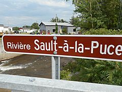
Rivière du Sault à la Puce facts for kids
Quick facts for kids Rivière du Sault à la Puce |
|
|---|---|
| Country | Canada |
| Province | Quebec |
| Region | Capitale-Nationale |
| Regional County Municipality | La Côte-de-Beaupré Regional County Municipality |
| Municipality | Château-Richer |
| Physical characteristics | |
| Main source | Lac du Sault à la Puce Château-Richer 494 m 47°05′41″N 71°10′29″W / 47.0947696°N 71.17482°W |
| River mouth | St. Lawrence River Château-Richer 4 m 46°58′42″N 71°00′28″W / 46.97833°N 71.00777°W |
| Length | 202 km (126 mi) |
| Basin features | |
| Tributaries |
|
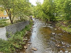
The Rivière du Sault à la Puce is a river in Quebec, Canada. It flows south into the famous St. Lawrence River. This river is located in the town of Château-Richer, which is part of the La Côte-de-Beaupré Regional County Municipality. This area is found in the Capitale-Nationale region.
The lower part of the river valley has roads like Avenue Royale and Route 138. These roads run along the north shore of the St. Lawrence River. The road to Saint-Achillée serves the middle and upper parts of the river. The main activity in this valley is forestry, which means cutting down trees. Tourism is also important, and some farming happens in the lower areas.
The river usually freezes from early December until late March. It's generally safe to walk on the ice from mid-December to mid-March. The amount of water in the river changes with the seasons and how much rain or snow falls. The biggest flood usually happens in March or April when the snow melts.
Where the River Flows
The Rivière du Sault à la Puce is surrounded by other rivers.
- To the west, you'll find the Le Moyne River and the Cazeau River.
- To the north and west, there's the Montmorency River.
- To the east, you can see the Rivière des Sept Crans and the Rivière aux Chiens North-West.
This river is about 20.2 kilometers (12.6 miles) long. It starts at a lake called Lac du Sault à la Puce, which is 494 meters (1,621 feet) above sea level. This lake is in the northern part of Château-Richer.
From its starting lake, the river flows south:
- It travels about 8.3 kilometers (5.2 miles) to a small village called Saint-Achille-de-Montmorency.
- Then, it goes another 5.5 kilometers (3.4 miles) to where a small river from Saint-Ignace joins it.
- Finally, it flows 6.4 kilometers (4 miles) more until it reaches its mouth, where it empties into the St. Lawrence River.
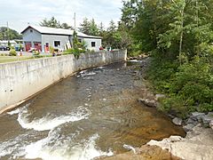
As the river flows downhill, it first goes through a mountainous area. Then, it has several small waterfalls. One of these waterfalls is 18 meters (59 feet) high and is found in a cliff known as "la Grande Côte." The river then passes through the towns of "Lefrançois" and "Sault-à-la-Puce." Near where the river meets the St. Lawrence River, there's a marina. A special wall called a breakwater protects this marina from big waves.
-
Upstream of the route 360
-
Downstream
-


How the River Got Its Name
The name "Rivière du Sault à la Puce" appeared on a map in 1641. It was spelled "Rivière du Sault à la Pusse" back then. A book from 1906 about Quebec's place names mentions the story behind it. On May 2, 1640, two men, Adrien d'Abancour and Etienne Sevestre, went hunting and sadly drowned.
An old record from Notre-Dame de Québec church says that someone named "Pulce" was sent to search for them. He looked everywhere, but couldn't find anything. He fired his gun many times to signal, but returned to Quebec without news.
This name, "Rivière du Sault à la Puce," helps us remember this person named Pulce. He gave his nickname to the river and to the "flea sault" (which means "flea jump" or "flea waterfall"). The name "Rivière du Sault à la Puce" was officially recognized on December 5, 1968.
River History and Activities
Forestry, which is the business of managing and cutting down trees, has always been very important for the economy of this region. In 1940, a sawmill was built along the "Sault à la Puce river." This mill created a lot of industrial activity for many years.
Since the 1800s, fun activities like tourism have become popular around the river. Along Route 138, there are many restaurants, hotels, and services for travelers. Most people in Château-Richer live in the area between the St. Lawrence River and a big cliff called "la Grande Côte."
