Rollersville, Ohio facts for kids
Quick facts for kids
Rollersville, Ohio
|
|
|---|---|

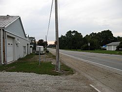
Rollersville, Ohio is bisected by the Grand Army of the Republic Highway.
|
|

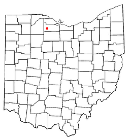
Location of Rollersville, Ohio
|
|
| Country | United States |
| State | Ohio |
| County | Sandusky |
| Elevation | 689 ft (210 m) |
| Time zone | UTC-5 (Eastern (EST)) |
| • Summer (DST) | UTC-4 (EDT) |
| Area code(s) | 419 |
| GNIS feature ID | 1065244 |
Rollersville is a small, quiet place in Ohio, United States. It's called an unincorporated community. This means it's not officially a city or town with its own local government. Instead, it's part of larger areas called Madison and Scott townships in Sandusky County.
You can find Rollersville right on the Grand Army of the Republic Highway, also known as U.S. Route 6. It's about 4.5 miles west of a town called Helena, Ohio. For many years, Rollersville even had its own post office, from 1839 until 1908.
A Look Back: Rollersville's Past
How Rollersville Got Its Name
Rollersville has an interesting history, even though it's a small community. It was named after a man named Henry Roller. He was a very important person in the early days of the area. Henry Roller was a War of 1812 veteran, meaning he fought in a war that happened a long time ago. He was also a pioneer settler, which means he was one of the first people to move to and live in this area.
The Old Post Office
One important part of Rollersville's past was its post office. A post office was first opened in Rollersville in 1839. This was a big deal because it helped people send and receive letters and packages. It connected the community to the rest of the world. The post office served the people of Rollersville for many years, until it finally closed down in 1908.
 | George Robert Carruthers |
 | Patricia Bath |
 | Jan Ernst Matzeliger |
 | Alexander Miles |

