
Saint John, Barbados facts for kids
Quick facts for kids
Saint John
|
|
|---|---|
 |
|

Map of Barbados showing the Saint John parish
|
|
| Country | Barbados |
| Largest city | Four Roads |
| Government | |
| • Type | Parliamentary democracy |
| Area | |
| • Total | 34 km2 (13 sq mi) |
| Population
(2010 census)
|
|
| • Total | 8,963 |
| • Density | 264/km2 (683/sq mi) |
| ISO 3166 code | BB-05 |
Saint John, often called "St. John", is one of the eleven areas known as parishes in Barbados. It is located on the eastern side of this beautiful island. Saint John is known for its lovely views and important places, including a well-known school. In its southeastern corner, the shoreline turns northward instead of southward, forming the small Conset Bay.
Contents
About Saint John
Saint John covers about 34 square kilometers (13 square miles) of land. In 2010, about 8,963 people lived here. The largest town in Saint John is called Four Roads. The parish is governed as part of Barbados's parliamentary democracy. This means people vote for representatives to make decisions.
Exploring Saint John
Saint John offers a mix of natural beauty and interesting spots. Its eastern coastline is especially scenic.
Natural Beauty and Coastline
The southeastern part of Saint John has a unique shoreline. Instead of continuing south, the coast turns northward, forming a small, pretty area known as Conset Bay. This bay is a quiet spot to enjoy the ocean.
Important Places in Saint John
This parish is home to some key landmarks.
The Lodge School
One of the main secondary schools on the island, The Lodge School, is located in Saint John. It is an important place for education in Barbados.
Ashford Bird Park
Ashford Bird Park is a special place where you can see many different kinds of birds and animals. It acts as a sanctuary, which means it's a safe home for these creatures. It's a great spot to learn about nature and wildlife.
Images for kids
-
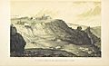
St. John's church and Hackelons cliff, 1848

See also
 In Spanish: Parroquia de Saint John (Barbados) para niños
