San Benito Abad facts for kids
Quick facts for kids
San Benito Abad
|
|
|---|---|
|
Municipality and town
|
|

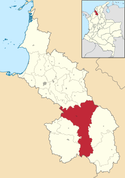
Location of the municipality and town of San Benito Abad in the Sucre Department of Colombia.
|
|
| Country | |
| Department | Sucre Department |
| Area | |
| • Land | 1,592 km2 (615 sq mi) |
| Elevation | 20 m (70 ft) |
| Population
(2015)
|
|
| • Municipality and town | 25,442 |
| • Urban | 5,314 |
| Demonym(s) | Sanbenitino |
| Time zone | UTC-5 (Colombia Standard Time) |
San Benito Abad is a town and a municipality located in the Sucre Department in northern Colombia. It is a place where many people live and work, and it's known for its warm weather.
Contents
Understanding the Climate in San Benito Abad
The climate in San Benito Abad is generally hot and humid throughout the year. This region experiences a tropical climate, which means there isn't a big difference between summer and winter temperatures.
Temperatures Throughout the Year
The average temperature in San Benito Abad is around 28 degrees Celsius (about 82 degrees Fahrenheit). The hottest months are usually February, March, and April, when temperatures can reach over 33 degrees Celsius (around 91 degrees Fahrenheit). Even the cooler months stay warm, with lows rarely dropping below 22 degrees Celsius (72 degrees Fahrenheit).
Rainfall and Humidity
San Benito Abad has a distinct rainy season. From April to November, the area receives a lot of rain. The wettest months are typically June, July, August, and September, with over 200 millimeters (about 8 inches) of rain each month. The air is also very humid, often around 80-83%, especially during the rainy season. The drier months are from December to March, with much less rainfall.
Sunshine in San Benito Abad
Even with the rain, San Benito Abad gets a good amount of sunshine. On average, the town sees about 5 to 8 hours of sunshine per day. The sunniest months are usually January and February.
| Climate data for San Benito Abad, elevation 20 m (66 ft), (1981–2010) | |||||||||||||
|---|---|---|---|---|---|---|---|---|---|---|---|---|---|
| Month | Jan | Feb | Mar | Apr | May | Jun | Jul | Aug | Sep | Oct | Nov | Dec | Year |
| Mean daily maximum °C (°F) | 32.5 (90.5) |
33.3 (91.9) |
33.8 (92.8) |
33.7 (92.7) |
32.6 (90.7) |
32.5 (90.5) |
32.2 (90.0) |
32.0 (89.6) |
31.9 (89.4) |
31.5 (88.7) |
31.6 (88.9) |
32.1 (89.8) |
32.4 (90.3) |
| Daily mean °C (°F) | 28.0 (82.4) |
28.4 (83.1) |
28.7 (83.7) |
28.6 (83.5) |
28.3 (82.9) |
28.2 (82.8) |
28.2 (82.8) |
28.1 (82.6) |
27.9 (82.2) |
27.8 (82.0) |
27.9 (82.2) |
27.9 (82.2) |
28.2 (82.8) |
| Mean daily minimum °C (°F) | 22.8 (73.0) |
23.0 (73.4) |
23.4 (74.1) |
23.7 (74.7) |
23.6 (74.5) |
23.4 (74.1) |
23.3 (73.9) |
23.0 (73.4) |
23.1 (73.6) |
23.3 (73.9) |
23.4 (74.1) |
23.2 (73.8) |
23.3 (73.9) |
| Average precipitation mm (inches) | 13.5 (0.53) |
14.7 (0.58) |
30.3 (1.19) |
114.7 (4.52) |
191.8 (7.55) |
227.2 (8.94) |
241.7 (9.52) |
252.3 (9.93) |
256.7 (10.11) |
216.0 (8.50) |
147.1 (5.79) |
50.7 (2.00) |
1,718.4 (67.65) |
| Average precipitation days | 1 | 2 | 3 | 7 | 13 | 14 | 15 | 15 | 15 | 15 | 11 | 4 | 113 |
| Average relative humidity (%) | 80 | 78 | 77 | 78 | 81 | 81 | 81 | 82 | 82 | 83 | 83 | 82 | 81 |
| Mean monthly sunshine hours | 254.2 | 217.4 | 192.2 | 171.0 | 161.2 | 189.0 | 217.0 | 210.8 | 171.0 | 179.8 | 180.0 | 223.2 | 2,366.8 |
| Mean daily sunshine hours | 8.2 | 7.7 | 6.2 | 5.7 | 5.2 | 6.3 | 7.0 | 6.8 | 5.7 | 5.8 | 6.0 | 7.2 | 6.5 |
| Source: Instituto de Hidrologia Meteorologia y Estudios Ambientales | |||||||||||||
See also
 In Spanish: San Benito Abad (Sucre) para niños
 | Kyle Baker |
 | Joseph Yoakum |
 | Laura Wheeler Waring |
 | Henry Ossawa Tanner |

