San Cristóbal, Bolívar facts for kids
Quick facts for kids
San Cristóbal
|
||
|---|---|---|
|
||

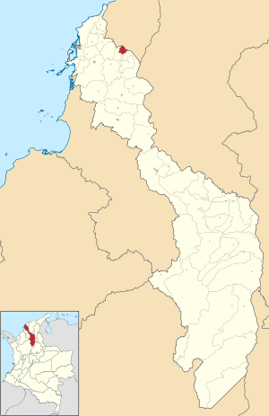
Location of the municipality and town of San Cristobal, Bolívar in the Bolívar Department of Colombia
|
||
| Country | ||
| Department | Bolivar | |
| Subregion | Dique | |
| Established | November 30, 1995 | |
| Area | ||
| • Total | 42.27 km2 (16.32 sq mi) | |
| Elevation | 7 m (23 ft) | |
| Population
(2018)
|
||
| • Total | 8,054 | |
| • Density | 190.54/km2 (493.49/sq mi) | |
| Demonym(s) | Sancristobano/a | |
| Time zone | UTC-5 (COT) | |
| Postal code |
131520
|
|
San Cristóbal is a small town in northern Colombia. It is a municipality, which means it's like a local government area. San Cristóbal is found in the Bolívar Department.
Contents
About San Cristóbal
San Cristóbal is located in the northern part of the Bolívar Department. It sits right on the southern edge of the Dique Canal. This canal is an important waterway.
Population and Size
In 2018, about 8,054 people lived in San Cristóbal. The town is quite small in size. It covers an area of about 42.27 square kilometers.
How High is San Cristóbal?
San Cristóbal is very close to sea level. Its average height is only 7 meters (about 23 feet) above the sea.
Who Leads San Cristóbal?
The leader of San Cristóbal is called the Mayor. The Mayor helps run the town and make decisions for the people. As of now, the Mayor is Carlos Manuel Julio Morales.
When Was San Cristóbal Established?
San Cristóbal was officially established as a municipality on November 30, 1995. This means it became its own recognized local government area on that date.
See also
 In Spanish: San Cristóbal (Bolívar) para niños
 | Leon Lynch |
 | Milton P. Webster |
 | Ferdinand Smith |


