San Gabriel Island facts for kids
|
Isla San Gabriel
|
|
|---|---|

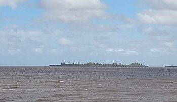
San Gabriel Island as seen from Colonia del Sacramento.
|
|
| Geography | |
| Location | Río de la Plata |
| Coordinates | 34°28′24″S 57°53′22″W / 34.47333°S 57.88944°W |
| Area | 24 ha (59 acres) |
| Length | 1.1 km (0.68 mi) |
| Width | 0.45 km (0.28 mi) |
| Administration | |
| Department | Colonia |
San Gabriel Island is a small island in Uruguay. It is found in the Río de la Plata, which is a very wide river. The island is close to the historic city of Colonia del Sacramento.
This island is quite small, about 1.1 kilometers long and 0.45 kilometers wide. It covers an area of about 24 hectares. That's like 24 football fields!
Where is San Gabriel Island?
San Gabriel Island is located in the Río de la Plata. This is a large estuary, or a wide part of a river where it meets the sea. It forms part of the border between Uruguay and Argentina. The island is very close to the coast of Uruguay. It sits just off the city of Colonia del Sacramento.
A Look at History
The island got its name from an explorer named Sebastian Cabot. He was a famous navigator who explored parts of South America. Cabot named the island in the year 1527. This was a long time ago, when many European explorers were mapping new lands.
Protecting Nature and History
San Gabriel Island is not just a piece of land. It is also a very important place. The island, along with nearby Farallón Island, has been named a National Monument. This means it is protected by the government. Being a National Monument helps to preserve its natural beauty and any historical importance it might have. It ensures that the island's environment and history are kept safe for future generations to enjoy and learn from.
See also
 In Spanish: Isla San Gabriel para niños
 | George Robert Carruthers |
 | Patricia Bath |
 | Jan Ernst Matzeliger |
 | Alexander Miles |

