
San Ignacio District, Acosta facts for kids
Quick facts for kids
San Ignacio
|
|
|---|---|
|
District
|
|
.JPG)
Church of San Ignacio de Loyola, Acosta, Costa Rica.
|
|

San Ignacio
Location in Costa Rica
|
|
| Country | |
| Province | San José |
| Canton | Acosta |
| Area | |
| • Total | 22.63 km2 (8.74 sq mi) |
| Elevation | 1,095 m (3,593 ft) |
| Population
(2011)
|
|
| • Total | 9,016 |
| • Density | 398.41/km2 (1,031.88/sq mi) |
| Time zone | UTC−06:00 |
| Postal code |
11201
|
San Ignacio is a cool district located in the Acosta area, which is part of the San José province in the beautiful country of Costa Rica. It's a place where many people live and enjoy the natural surroundings.
Contents
About San Ignacio's Location
San Ignacio covers an area of about 22.63 square kilometers. That's like a square with sides just under 5 kilometers long! It sits at an elevation of 1095 meters above sea level. This means it's quite high up, which can make for cooler temperatures and nice views.
Who Lives in San Ignacio?
| Historical population | |||
|---|---|---|---|
| Census | Pop. | %± | |
| 1883 | 697 | — | |
| 1892 | 827 | 18.7% | |
| 1927 | 2,125 | 157.0% | |
| 1950 | 2,184 | 2.8% | |
| 1963 | 3,322 | 52.1% | |
| 1973 | 4,420 | 33.1% | |
| 1984 | 5,036 | 13.9% | |
| 2000 | 7,728 | 53.5% | |
| 2011 | 9,016 | 16.7% | |
|
Instituto Nacional de Estadística y Censos |
|||
According to the census from 2011, San Ignacio had a population of 9016 people. This number shows how the district has grown over the years, with more and more people choosing to call San Ignacio home.
Getting Around San Ignacio
Main Roads in the District
If you want to travel by road in San Ignacio, you'll find that the district is connected by a few important routes. These roads help people get to and from San Ignacio and other parts of Costa Rica.
The main road routes that pass through San Ignacio are:
 National Route 209
 National Route 301
These routes are like the main highways that help everyone, from residents to visitors, explore the area.
Images for kids
-
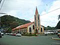
The Church of San Ignacio de Loyola, a beautiful building in the district.
Learn More
 Want to read about San Ignacio in Spanish? Check out this link: San Ignacio de Acosta para niños
