
San Jerónimo (Los Barbosa) facts for kids
San Jerónimo (Los Barbosa) is a small town in Jalisco, Mexico. It's part of the San Martín de Hidalgo Municipality. In 2010, about 355 people lived there, making it the eleventh-largest town in its municipality. It's also the second-largest in its local area, called a territorial sub-committee.
This town is located about 45 miles southwest of Guadalajara and 80 miles east of Puerto Vallarta. It is also home to the San Jerónimo Dam, which was built with money from the state.
Quick facts for kids
San Jerónimo (Los Barbosa)
|
|||
|---|---|---|---|
|
Locality and Municipal Agency
|
|||
.jpg)
Central view of San Jerónimo
|
|||
|
|||

San Jerónimo (Los Barbosa)
Location in Jalisco

San Jerónimo (Los Barbosa)
Location in Mexico
|
|||
| Country | |||
| State | |||
| Region | Valles | ||
| Municipality | San Martín de Hidalgo | ||
| Territorial sub-committee | Santa Cruz de las Flores | ||
| Incorporated | March 25, 1925 | ||
| Government | |||
| • Type | Municipal Agency | ||
| Elevation | 4,842 ft (1,476 m) | ||
| Population
(2010)
|
|||
| • Total | 355 | ||
| • Rank | 11th in San Martín de Hidalgo Municipality | ||
| Demonym(s) | Barboseño | ||
| Time zone | UTC-6 (Central Standard Time) | ||
| • Summer (DST) | UTC-5 (Central Daylight Time) | ||
| Website | Official website: http://sanjeronimolb.yolasite.com | ||


Contents
History of San Jerónimo
The town of San Jerónimo was first written about in 1744. At that time, it was listed as one of the places under the control of Cocula, a nearby area.
Population Information
How Many People Live Here?
According to a count done in 2010, San Jerónimo (Los Barbosa) had 355 residents. Out of these, 164 were boys or men, and 191 were girls or women. There were 103 houses where people lived.
| Historical population | ||
|---|---|---|
| Year | Pop. | ±% |
| 1900 | 360 | — |
| 1910 | 277 | −23.1% |
| 1921 | 310 | +11.9% |
| 1930 | 428 | +38.1% |
| 1940 | 401 | −6.3% |
| 1950 | 445 | +11.0% |
| 1960 | 458 | +2.9% |
| 1970 | 515 | +12.4% |
| 1980 | 506 | −1.7% |
| 1990 | 494 | −2.4% |
| 1995 | 493 | −0.2% |
| 2000 | 465 | −5.7% |
| 2005 | 341 | −26.7% |
| 2010 | 355 | +4.1% |
| Source: INEGI | ||
Farming and Land
On March 25, 1925, San Jerónimo became an ejido. An ejido is a special type of land ownership in Mexico where land is owned by the community. The town received about 582 hectares of land for its community to use for farming and other activities.
Nearby Communities
San Jerónimo is connected to a few smaller communities:
- La Madera is considered part of the main village.
- Planta de Beneficio used to be a settlement just outside the village.
Other Localities
There are also other small places nearby:
- El Cerrito de los Tapia
- La Barranca de San Jerónimo
Images for kids
-
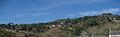
Central view of San Jerónimo
-

Flag of San Jerónimo
-
Seal of San Jerónimo
See also
 In Spanish: San Jerónimo (Los Barbosa) para niños
