San Miguel, Santander facts for kids
Quick facts for kids
San Miguel
|
||
|---|---|---|
|
Municipality and town
|
||
|
||

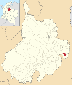
Location of the municipality and town of San Miguel in the Santander Department of Colombia
|
||
| Country | ||
| Department | Santander Department | |
| Time zone | UTC-5 (Colombia Standard Time) | |
San Miguel is a town and municipality located in the Santander Department in northeastern Colombia. It is a place with a fascinating history and important natural features.
Contents
History of San Miguel
San Miguel has a long and interesting past, starting from its early days as a settlement to becoming an official municipality.
Early Beginnings
The town of San Miguel was officially founded on January 28, 1763. It was established by three siblings: Nicolás, Miguel, and Margarita Suárez. Before this, the area was a borderland between different indigenous groups like the Laches and Chitareros. It was known as the "Valley of Honey" because of its many sugarcane fields and sugar mills.
In 1657, the people living in the Valley of Honey wanted their own church. They asked for permission to build a chapel in a place called Balagula. Their request was approved, and a parish was founded under the name of San Miguel. This name honored Mr. Miguel Palencia, who helped promote the idea.
Becoming a Municipality
By 1762, San Miguel had a strong church building. The residents then decided they wanted their own official parish. This idea was approved on August 11, 1762.
Later, in 1870, a decree by President Salgar changed the name of municipalities to parishes. However, after a new constitution in 1886, San Miguel regained its status as a municipal district in September 1877. This meant it became an independent local government area again.
Where is San Miguel? (Geography)
San Miguel is located in a beautiful part of Colombia with diverse landscapes.
Location and Neighbors
San Miguel is found in the far southeast of the García Rovira province, which is in the eastern part of the Santander Department. It shares borders with several other municipalities:
- To the North: Enciso and Carcasí
- To the East: Carcasí
- To the South: Macaravita and part of Capitanejo
- To the West: Capitanejo
Climate and Size
San Miguel has both temperate and cold climates. This means it's not too hot and can get quite cool. The average temperature is about 18 °C (64 °F). The area receives about 1200 millimeters of rain each year.
The main town of San Miguel is located at an altitude of 2200 meters (about 7218 feet) above sea level.
- Total area: 71 square kilometers (about 27.4 square miles)
- Urban area (town center): 0.09 square kilometers
- Rural area (countryside): 70.91 square kilometers
What San Miguel Does (Economy)
The economy of San Miguel mainly relies on activities related to the land. These activities provide jobs, income, and food for the people living there.
Farming and Crops
Agriculture is the biggest part of San Miguel's economy. It helps families earn money and ensures there is enough food for everyone. Farmers grow various crops that are important for the region's food supply.
Raising Animals
Livestock farming is also very important in San Miguel. It provides income for many families, especially those with small and medium-sized farms. Raising animals offers high-quality protein like meat and milk for the community.
Farmers in San Miguel raise different types of animals:
- Cattle: For both milk and meat.
- Goats and pigs.
- Working horses.
- Poultry: Chickens for eggs and meat.
- Fish: Recently, fish farming has also started to grow in the area.
See also
 In Spanish: San Miguel (Santander) para niños
 | Shirley Ann Jackson |
 | Garett Morgan |
 | J. Ernest Wilkins Jr. |
 | Elijah McCoy |


