
Santa Lucía District facts for kids
Quick facts for kids
Santa Lucía
|
|
|---|---|
|
District
|
|

Adobe home and gardens of former president Alfredo Gonzalez Flores at the Popular Culture Museum in Santa Lucía district.
|
|

Santa Lucía
Location in Costa Rica
|
|
| Country | |
| Province | Heredia |
| Canton | Barva |
| Area | |
| • Total | 2.87 km2 (1.11 sq mi) |
| Elevation | 1,159 m (3,802 ft) |
| Population
(2011)
|
|
| • Total | 7,413 |
| • Density | 2,583/km2 (6,690/sq mi) |
| Time zone | UTC−06:00 |
| Postal code |
40205
|
Santa Lucía is a district located in the Barva canton, which is part of the Heredia province in Costa Rica. It's a lively community and one of the five districts that make up the Barva canton.
Contents
What's in a Name?
The name Santa Lucía comes from Saint Lucia of Syracuse. She was a Christian saint.
A Look Back in Time
The 1998 Tornado
On September 22, 1998, a strong wind event, like a small tornado, hit Santa Lucía. It lasted about 10 minutes. This event damaged 179 houses and affected around 600 people. Even though it caused a lot of damage, the National Weather Institute (Instituto Meteorológico Nacional) described it as a weak storm.
Exploring Santa Lucía's Geography
Santa Lucía covers an area of about 2.87 square kilometers. It sits at an elevation of 1159 meters above sea level.
It is located in the Greater Metropolitan Area. This is a large, busy region in the central valley of Costa Rica. Santa Lucía shares its borders with several other districts:
- To the north: Barva and San Pablo districts (both in Barva canton).
- To the east: Ángeles district (in San Rafael canton).
- To the south: San Josecito district (in San Rafael canton).
- To the west: Mercedes district (in Heredia canton).
Three small rivers, called quebradas in Spanish, flow through the district from east to west. These are Seca creek, Burío creek, and Palmar creek. Burío and Palmar creeks join together to form the Burío river. This river marks the southern edge of the district.
Where People Live: Residential Areas
Santa Lucía has many places where people live. These are often planned communities or neighborhoods. Some of these include:
- Urbanización Jardines de Santa Lucía
- Urbanización Antiesquivo
- Residencial Jardines del Beneficio
- Residencial Malinche Real
- Urbanización Villa Esmeralda
- Residencial La Ronda
- Urbanización Don Álvaro
- Urbanización Doña Iris
- Urbanización El Tajo
How Many People Live Here?
| Historical population | |||
|---|---|---|---|
| Census | Pop. | %± | |
| 1883 | 159 | — | |
| 1892 | 252 | 58.5% | |
| 1927 | 250 | −0.8% | |
| 1950 | 627 | 150.8% | |
| 1963 | 1,187 | 89.3% | |
| 1973 | 1,608 | 35.5% | |
| 1984 | 2,560 | 59.2% | |
| 2000 | 5,462 | 113.4% | |
| 2011 | 7,413 | 35.7% | |
|
Instituto Nacional de Estadística y Censos |
|||
According to the 2011 census, Santa Lucía had a population of 7,413 people.
Santa Lucía's Economy
Santa Lucía is mainly a place where people live. It has many small businesses that serve the needs of its residents.
There is also a coffee processing plant still working here. It's called Beneficio de Café Juan León e Hijos. You can also find small coffee farms in the area.
Learning and Education
Public Schools and Daycare
Santa Lucía has a public daycare center called Sueños de Algodón (Cotton Dreams). It also has a public primary school named Escuela Domingo González Pérez.
The National University of Costa Rica (UNA) has research facilities here. These are part of its Agrarian Sciences School (Escuela de Ciencias Agrarias). They are known as the Santa Lucía Experimental Farm (Finca Experimental Santa Lucía). The university's Forest Research and Services Institute (Instituto de Investigación y Servicios Forestales) is also located in the district.
Private Schools and Daycare
For private education, there is a preschool and daycare center called Centro Educativo Bilingüe Cosquillitas.
There are also two private schools:
- Centro Educativo Montealto: This school teaches preschool, primary school, and high school students.
- Centro Educativo Shkénuk Montessori: This is a Montessori-style school.
Culture and Fun in Santa Lucía
Popular Culture Museum
The Museo de Cultura Popular (Popular Culture Museum) is located in Santa Lucía. It's a great place to learn about the local culture and history.
Community and Leisure
Santa Lucía has a community center (Salón Comunal). There are also several urban parks and a public soccer field for sports and outdoor activities.
The National University of Costa Rica's workers union has a leisure center (Centro de Recreo) in the district.
Religion
In 2002, the Catholic church in Santa Lucía, called Iglesia de Santa Lucía Virgen y Mártir, became its own parish. A parish is a church that serves a specific area. Before this, it was part of the Barva district's main church. Now, it has its own smaller church, Iglesia de la Medalla Milagrosa, in the nearby San Josecito district.
Getting Around Santa Lucía
Roads for Cars and Buses
The district is connected by these main road routes:
 National Route 126
 National Route 502
There are no train lines in Santa Lucía. People mostly use bus lines and taxis to get around.
Public Services
The Heredia Public Utilities Company (Empresa de Servicios Públicos de Heredia), or ESPH, provides electricity and clean drinking water to the district. They have two water wells, Pozo Santa Lucía and Pozo Malinche Real, to get water. They also have two water tanks, Tanque Antiesquivo and Tanque Santa Lucía, to store water for residents.
Currently, homes in the community use septic tanks for wastewater. ESPH has plans to build a sewage treatment plant for Santa Lucía and nearby areas.
For communication, residents have access to fast internet through fiber optic cables. Cable television and full cell phone service are also available from providers like ICE Kölbi, Claro, and Movistar.
Images for kids
-
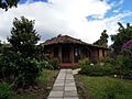
Adobe home and gardens of former president Alfredo Gonzalez Flores at the Popular Culture Museum in Santa Lucía district.
See also
 In Spanish: Santa Lucía de Barva para niños
