Santa María de la Alameda facts for kids
Quick facts for kids
Santa María de la Alameda
|
|||
|---|---|---|---|
 |
|||
|
|||
 |
|||
| Country | Spain | ||
| Region | Community of Madrid | ||
| Area | |||
| • Total | 74.41 km2 (28.73 sq mi) | ||
| Elevation | 1,409 m (4,623 ft) | ||
| Population
(2018)
|
|||
| • Total | 1,182 | ||
| • Density | 15.885/km2 (41.142/sq mi) | ||
| Time zone | UTC+1 (CET) | ||
| • Summer (DST) | UTC+2 (CEST) | ||
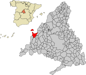
Santa María de la Alameda is a small town in the Community of Madrid, Spain. It is easy to reach from the city of Madrid by train. Many people visit Santa María de la Alameda on weekends and holidays. It is a great place for fishing, hunting, hiking, and other outdoor activities.
Contents
About Santa María de la Alameda
Santa María de la Alameda started as a group of small villages. These villages were mainly for raising cattle. Today, the area includes several settlements. These include Las Herreras, El Pimpollar, La Hoya, Navalespino, La Paradilla, Robledondo, and Santa María de la Alameda itself. There is also a place called Santa María Estación.
The Main Village
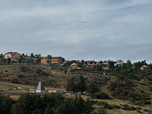
The village of Santa María de la Alameda is located high up. It sits at an elevation of 1,409 meters (about 4,623 feet). This makes it a cool place to visit, especially in summer.
Santa María Estación
Over time, the area around the railway station grew a lot. This part is called "Santa María Estación." It has become the most populated area in the municipality.
Size and Location
The municipality of Santa María de la Alameda covers an area of about 74.41 square kilometers. This is roughly 28.73 square miles. Part of this area is a special section called Dehesa de la Cepeda. This part is mostly pasture land. It is located between the provinces of Ávila and Segovia. These provinces are in the region of Castile and León.
See also
 In Spanish: Santa María de la Alameda para niños
 | Emma Amos |
 | Edward Mitchell Bannister |
 | Larry D. Alexander |
 | Ernie Barnes |


